You are here: Home > Network List > TA - USArray Transportable Network (new EarthScope stations) Stations List
> Station L15K Ungalak Mountain, AK, USA > Earthquake Result Viewer
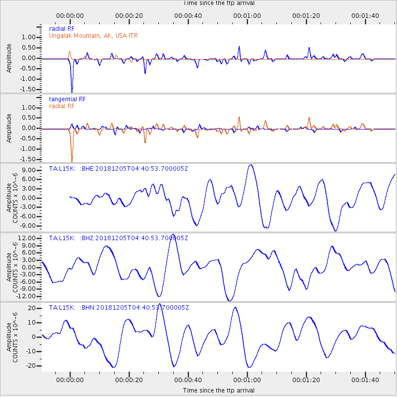
L15K Ungalak Mountain, AK, USA - Earthquake Result Viewer
*The percent match for this event was below the threshold and hence no stack was calculated.
| Earthquake location: |
Southeast Of Loyalty Islands |
| Earthquake latitude/longitude: |
-21.5/169.4 |
| Earthquake time(UTC): |
2018/12/05 (339) 04:28:44 GMT |
| Earthquake Depth: |
10 km |
| Earthquake Magnitude: |
5.9 mb |
| Earthquake Catalog/Contributor: |
NEIC PDE/us |
|
| Network: |
TA USArray Transportable Network (new EarthScope stations) |
| Station: |
L15K Ungalak Mountain, AK, USA |
| Lat/Lon: |
61.68 N/161.49 W |
| Elevation: |
219 m |
|
| Distance: |
86.1 deg |
| Az: |
13.462 deg |
| Baz: |
207.035 deg |
| Ray Param: |
$rayparam |
*The percent match for this event was below the threshold and hence was not used in the summary stack. |
|
| Radial Match: |
71.61325 % |
| Radial Bump: |
268 |
| Transverse Match: |
57.29084 % |
| Transverse Bump: |
236 |
| SOD ConfigId: |
13570011 |
| Insert Time: |
2019-05-02 00:25:55.733 +0000 |
| GWidth: |
2.5 |
| Max Bumps: |
400 |
| Tol: |
0.001 |
|
Signal To Noise
| Channel | StoN | STA | LTA |
| TA:L15K: :BHZ:20181205T04:40:53.700005Z | 1.1810694 | 2.670661E-6 | 2.2612228E-6 |
| TA:L15K: :BHN:20181205T04:40:53.700005Z | 3.3560185 | 6.259903E-6 | 1.8652765E-6 |
| TA:L15K: :BHE:20181205T04:40:53.700005Z | 1.9178643 | 2.808411E-6 | 1.464343E-6 |
| Arrivals |
| Ps | |
| PpPs | |
| PsPs/PpSs | |


