You are here: Home > Network List > TA - USArray Transportable Network (new EarthScope stations) Stations List
> Station A15A Johnson Ranch, Cut Bank, MT, USA > Earthquake Result Viewer
A15A Johnson Ranch, Cut Bank, MT, USA - Earthquake Result Viewer
| Earthquake location: |
Tonga Islands |
| Earthquake latitude/longitude: |
-21.9/-173.8 |
| Earthquake time(UTC): |
2008/10/19 (293) 05:10:33 GMT |
| Earthquake Depth: |
29 km |
| Earthquake Magnitude: |
6.8 MB, 7.0 MS, 6.9 MW, 6.9 MW |
| Earthquake Catalog/Contributor: |
WHDF/NEIC |
|
| Network: |
TA USArray Transportable Network (new EarthScope stations) |
| Station: |
A15A Johnson Ranch, Cut Bank, MT, USA |
| Lat/Lon: |
48.98 N/112.73 W |
| Elevation: |
1236 m |
|
| Distance: |
89.0 deg |
| Az: |
35.227 deg |
| Baz: |
234.416 deg |
| Ray Param: |
0.042133592 |
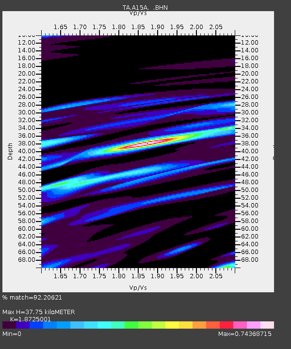
| Estimated Moho Depth: |
37.75 km |
| Estimated Crust Vp/Vs: |
1.87 |
| Assumed Crust Vp: |
6.178 km/s |
| Estimated Crust Vs: |
3.299 km/s |
| Estimated Crust Poisson's Ratio: |
0.30 |
|
| Radial Match: |
92.20621 % |
| Radial Bump: |
372 |
| Transverse Match: |
74.05963 % |
| Transverse Bump: |
400 |
| SOD ConfigId: |
2556 |
| Insert Time: |
2010-03-06 18:32:23.764 +0000 |
| GWidth: |
2.5 |
| Max Bumps: |
400 |
| Tol: |
0.001 |
|
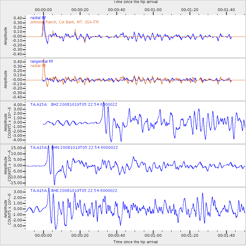
Signal To Noise
| Channel | StoN | STA | LTA |
| TA:A15A: :BHN:20081019T05:22:54.600002Z | 50.653107 | 6.9395937E-6 | 1.3700233E-7 |
| TA:A15A: :BHE:20081019T05:22:54.600002Z | 6.4622593 | 1.5957839E-6 | 2.46939E-7 |
| TA:A15A: :BHZ:20081019T05:22:54.600002Z | 6.6544156 | 1.9374738E-6 | 2.911561E-7 |
| Arrivals |
| Ps | 5.4 SECOND |
| PpPs | 17 SECOND |
| PsPs/PpSs | 23 SECOND |


