You are here: Home > Network List > TA - USArray Transportable Network (new EarthScope stations) Stations List
> Station P17K Kvichak River, AK, USA > Earthquake Result Viewer
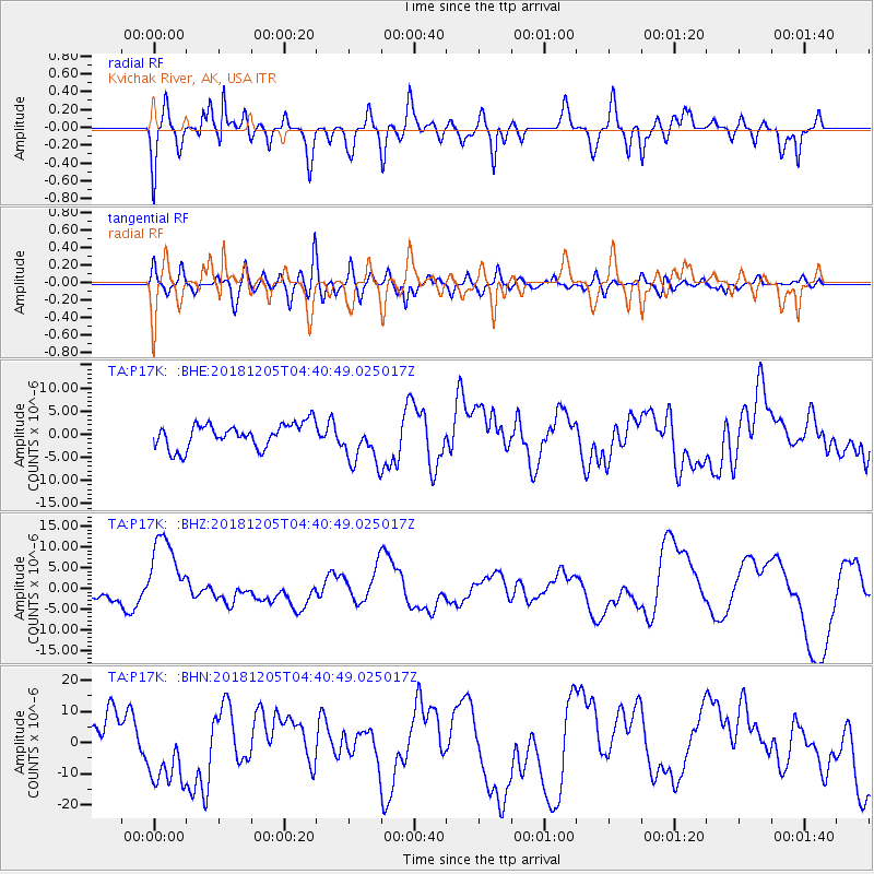
P17K Kvichak River, AK, USA - Earthquake Result Viewer
*The percent match for this event was below the threshold and hence no stack was calculated.
| Earthquake location: |
Southeast Of Loyalty Islands |
| Earthquake latitude/longitude: |
-21.5/169.4 |
| Earthquake time(UTC): |
2018/12/05 (339) 04:28:44 GMT |
| Earthquake Depth: |
10 km |
| Earthquake Magnitude: |
5.9 mb |
| Earthquake Catalog/Contributor: |
NEIC PDE/us |
|
| Network: |
TA USArray Transportable Network (new EarthScope stations) |
| Station: |
P17K Kvichak River, AK, USA |
| Lat/Lon: |
59.20 N/156.44 W |
| Elevation: |
91 m |
|
| Distance: |
85.2 deg |
| Az: |
16.873 deg |
| Baz: |
211.678 deg |
| Ray Param: |
$rayparam |
*The percent match for this event was below the threshold and hence was not used in the summary stack. |
|
| Radial Match: |
46.28895 % |
| Radial Bump: |
368 |
| Transverse Match: |
51.097424 % |
| Transverse Bump: |
400 |
| SOD ConfigId: |
13570011 |
| Insert Time: |
2019-05-02 00:26:27.316 +0000 |
| GWidth: |
2.5 |
| Max Bumps: |
400 |
| Tol: |
0.001 |
|
Signal To Noise
| Channel | StoN | STA | LTA |
| TA:P17K: :BHZ:20181205T04:40:49.025017Z | 7.589613 | 9.726926E-6 | 1.2816103E-6 |
| TA:P17K: :BHN:20181205T04:40:49.025017Z | 2.4880235 | 1.1166962E-5 | 4.488287E-6 |
| TA:P17K: :BHE:20181205T04:40:49.025017Z | 1.8713367 | 4.92606E-6 | 2.632375E-6 |
| Arrivals |
| Ps | |
| PpPs | |
| PsPs/PpSs | |


