You are here: Home > Network List > TA - USArray Transportable Network (new EarthScope stations) Stations List
> Station A15A Johnson Ranch, Cut Bank, MT, USA > Earthquake Result Viewer
A15A Johnson Ranch, Cut Bank, MT, USA - Earthquake Result Viewer

| Earthquake location: |
Bonin Islands, Japan Region |
| Earthquake latitude/longitude: |
26.8/142.4 |
| Earthquake time(UTC): |
2008/02/27 (058) 06:54:20 GMT |
| Earthquake Depth: |
15 km |
| Earthquake Magnitude: |
5.8 MB, 6.1 MS, 6.2 MW, 6.2 MW |
| Earthquake Catalog/Contributor: |
WHDF/NEIC |
|
| Network: |
TA USArray Transportable Network (new EarthScope stations) |
| Station: |
A15A Johnson Ranch, Cut Bank, MT, USA |
| Lat/Lon: |
48.98 N/112.73 W |
| Elevation: |
1236 m |
|
| Distance: |
79.2 deg |
| Az: |
40.416 deg |
| Baz: |
298.43 deg |
| Ray Param: |
0.049093734 |
| Estimated Moho Depth: |
29.5 km |
| Estimated Crust Vp/Vs: |
2.10 |
| Assumed Crust Vp: |
6.178 km/s |
| Estimated Crust Vs: |
2.946 km/s |
| Estimated Crust Poisson's Ratio: |
0.35 |
|
| Radial Match: |
82.2446 % |
| Radial Bump: |
258 |
| Transverse Match: |
76.42309 % |
| Transverse Bump: |
400 |
| SOD ConfigId: |
2564 |
| Insert Time: |
2010-03-06 18:32:34.103 +0000 |
| GWidth: |
2.5 |
| Max Bumps: |
400 |
| Tol: |
0.001 |
|
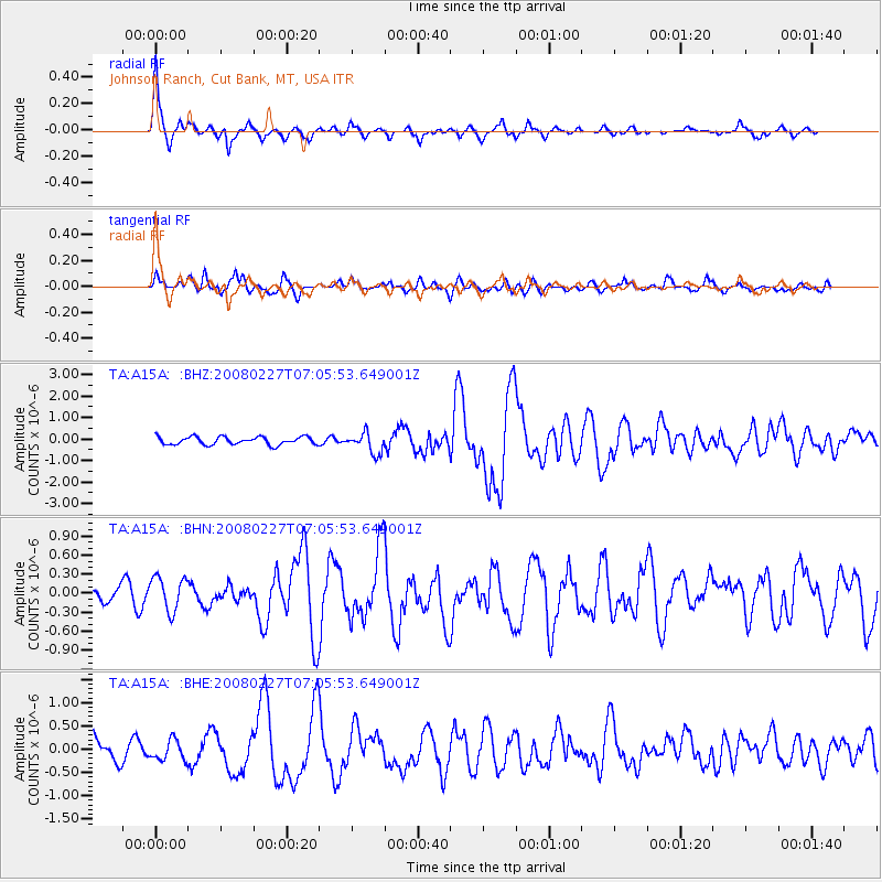
Signal To Noise
| Channel | StoN | STA | LTA |
| TA:A15A: :BHN:20080227T07:05:53.649001Z | 1.5965208 | 2.6370066E-7 | 1.6517208E-7 |
| TA:A15A: :BHE:20080227T07:05:53.649001Z | 0.802236 | 2.1480486E-7 | 2.6775768E-7 |
| TA:A15A: :BHZ:20080227T07:05:53.649001Z | 2.6502264 | 4.785926E-7 | 1.8058556E-7 |
| Arrivals |
| Ps | 5.4 SECOND |
| PpPs | 14 SECOND |
| PsPs/PpSs | 20 SECOND |


