You are here: Home > Network List > TA - USArray Transportable Network (new EarthScope stations) Stations List
> Station A15A Johnson Ranch, Cut Bank, MT, USA > Earthquake Result Viewer
A15A Johnson Ranch, Cut Bank, MT, USA - Earthquake Result Viewer

| Earthquake location: |
Guatemala |
| Earthquake latitude/longitude: |
14.1/-91.5 |
| Earthquake time(UTC): |
2008/01/05 (005) 01:56:45 GMT |
| Earthquake Depth: |
66 km |
| Earthquake Magnitude: |
5.6 MW, 5.4 MB, 5.6 MW |
| Earthquake Catalog/Contributor: |
WHDF/NEIC |
|
| Network: |
TA USArray Transportable Network (new EarthScope stations) |
| Station: |
A15A Johnson Ranch, Cut Bank, MT, USA |
| Lat/Lon: |
48.98 N/112.73 W |
| Elevation: |
1236 m |
|
| Distance: |
38.9 deg |
| Az: |
337.648 deg |
| Baz: |
145.947 deg |
| Ray Param: |
0.07509724 |
| Estimated Moho Depth: |
67.5 km |
| Estimated Crust Vp/Vs: |
2.06 |
| Assumed Crust Vp: |
6.178 km/s |
| Estimated Crust Vs: |
2.996 km/s |
| Estimated Crust Poisson's Ratio: |
0.35 |
|
| Radial Match: |
82.66194 % |
| Radial Bump: |
389 |
| Transverse Match: |
76.244064 % |
| Transverse Bump: |
400 |
| SOD ConfigId: |
2564 |
| Insert Time: |
2010-03-06 18:32:36.190 +0000 |
| GWidth: |
2.5 |
| Max Bumps: |
400 |
| Tol: |
0.001 |
|
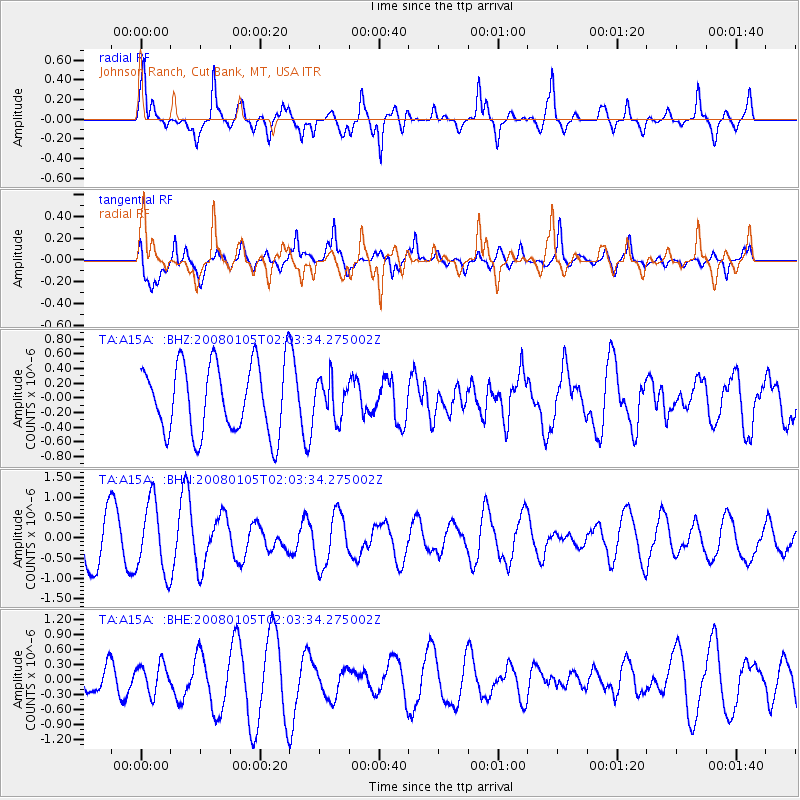
Signal To Noise
| Channel | StoN | STA | LTA |
| TA:A15A: :BHN:20080105T02:03:34.275002Z | 1.6466742 | 8.713055E-7 | 5.291305E-7 |
| TA:A15A: :BHE:20080105T02:03:34.275002Z | 0.6358199 | 2.9528607E-7 | 4.6441778E-7 |
| TA:A15A: :BHZ:20080105T02:03:34.275002Z | 0.5480602 | 2.588809E-7 | 4.7235858E-7 |
| Arrivals |
| Ps | 12 SECOND |
| PpPs | 32 SECOND |
| PsPs/PpSs | 44 SECOND |


