You are here: Home > Network List > UW - Pacific Northwest Regional Seismic Network Stations List
> Station HEBO Mt. Hebo, OR CREST BB SMO > Earthquake Result Viewer
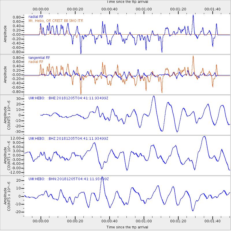
HEBO Mt. Hebo, OR CREST BB SMO - Earthquake Result Viewer
*The percent match for this event was below the threshold and hence no stack was calculated.
| Earthquake location: |
Southeast Of Loyalty Islands |
| Earthquake latitude/longitude: |
-21.5/169.4 |
| Earthquake time(UTC): |
2018/12/05 (339) 04:28:44 GMT |
| Earthquake Depth: |
10 km |
| Earthquake Magnitude: |
5.9 mb |
| Earthquake Catalog/Contributor: |
NEIC PDE/us |
|
| Network: |
UW Pacific Northwest Regional Seismic Network |
| Station: |
HEBO Mt. Hebo, OR CREST BB SMO |
| Lat/Lon: |
45.21 N/123.76 W |
| Elevation: |
875 m |
|
| Distance: |
90.0 deg |
| Az: |
40.546 deg |
| Baz: |
238.911 deg |
| Ray Param: |
$rayparam |
*The percent match for this event was below the threshold and hence was not used in the summary stack. |
|
| Radial Match: |
40.95174 % |
| Radial Bump: |
400 |
| Transverse Match: |
36.089096 % |
| Transverse Bump: |
400 |
| SOD ConfigId: |
13570011 |
| Insert Time: |
2019-05-02 00:27:31.250 +0000 |
| GWidth: |
2.5 |
| Max Bumps: |
400 |
| Tol: |
0.001 |
|
Signal To Noise
| Channel | StoN | STA | LTA |
| UW:HEBO: :BHZ:20181205T04:41:11.93499Z | 1.0363939 | 1.9538352E-6 | 1.8852245E-6 |
| UW:HEBO: :BHN:20181205T04:41:11.93499Z | 2.8238397 | 3.8762637E-6 | 1.3726926E-6 |
| UW:HEBO: :BHE:20181205T04:41:11.93499Z | 3.805037 | 8.869296E-6 | 2.3309356E-6 |
| Arrivals |
| Ps | |
| PpPs | |
| PsPs/PpSs | |


