You are here: Home > Network List > TA - USArray Transportable Network (new EarthScope stations) Stations List
> Station A15A Johnson Ranch, Cut Bank, MT, USA > Earthquake Result Viewer
A15A Johnson Ranch, Cut Bank, MT, USA - Earthquake Result Viewer

| Earthquake location: |
Sea Of Okhotsk |
| Earthquake latitude/longitude: |
54.2/154.3 |
| Earthquake time(UTC): |
2008/11/24 (329) 09:02:58 GMT |
| Earthquake Depth: |
492 km |
| Earthquake Magnitude: |
6.5 MB, 7.3 MW, 7.3 MW |
| Earthquake Catalog/Contributor: |
WHDF/NEIC |
|
| Network: |
TA USArray Transportable Network (new EarthScope stations) |
| Station: |
A15A Johnson Ranch, Cut Bank, MT, USA |
| Lat/Lon: |
48.98 N/112.73 W |
| Elevation: |
1236 m |
|
| Distance: |
53.9 deg |
| Az: |
54.499 deg |
| Baz: |
313.453 deg |
| Ray Param: |
0.06373821 |
| Estimated Moho Depth: |
18.5 km |
| Estimated Crust Vp/Vs: |
2.10 |
| Assumed Crust Vp: |
6.178 km/s |
| Estimated Crust Vs: |
2.946 km/s |
| Estimated Crust Poisson's Ratio: |
0.35 |
|
| Radial Match: |
85.16239 % |
| Radial Bump: |
367 |
| Transverse Match: |
73.04334 % |
| Transverse Bump: |
400 |
| SOD ConfigId: |
2658 |
| Insert Time: |
2010-03-06 18:32:51.752 +0000 |
| GWidth: |
2.5 |
| Max Bumps: |
400 |
| Tol: |
0.001 |
|
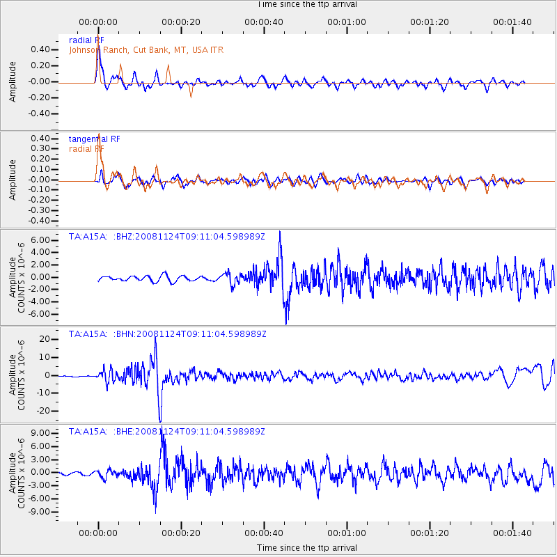
Signal To Noise
| Channel | StoN | STA | LTA |
| TA:A15A: :BHN:20081124T09:11:04.598989Z | 10.028152 | 3.2065714E-6 | 3.1975696E-7 |
| TA:A15A: :BHE:20081124T09:11:04.598989Z | 1.9438583 | 8.61929E-7 | 4.4341144E-7 |
| TA:A15A: :BHZ:20081124T09:11:04.598989Z | 2.0809326 | 8.912152E-7 | 4.2827685E-7 |
| Arrivals |
| Ps | 3.4 SECOND |
| PpPs | 8.9 SECOND |
| PsPs/PpSs | 12 SECOND |


