You are here: Home > Network List > TA - USArray Transportable Network (new EarthScope stations) Stations List
> Station A15A Johnson Ranch, Cut Bank, MT, USA > Earthquake Result Viewer
A15A Johnson Ranch, Cut Bank, MT, USA - Earthquake Result Viewer

| Earthquake location: |
North Of Svalbard |
| Earthquake latitude/longitude: |
80.3/-1.9 |
| Earthquake time(UTC): |
2009/03/06 (065) 10:50:29 GMT |
| Earthquake Depth: |
9.0 km |
| Earthquake Magnitude: |
6.6 MB, 6.5 MS, 6.5 MW, 6.4 MW |
| Earthquake Catalog/Contributor: |
WHDF/NEIC |
|
| Network: |
TA USArray Transportable Network (new EarthScope stations) |
| Station: |
A15A Johnson Ranch, Cut Bank, MT, USA |
| Lat/Lon: |
48.98 N/112.73 W |
| Elevation: |
1236 m |
|
| Distance: |
45.4 deg |
| Az: |
300.229 deg |
| Baz: |
12.818 deg |
| Ray Param: |
0.07128165 |
| Estimated Moho Depth: |
66.5 km |
| Estimated Crust Vp/Vs: |
1.78 |
| Assumed Crust Vp: |
6.178 km/s |
| Estimated Crust Vs: |
3.476 km/s |
| Estimated Crust Poisson's Ratio: |
0.27 |
|
| Radial Match: |
87.774445 % |
| Radial Bump: |
400 |
| Transverse Match: |
76.276985 % |
| Transverse Bump: |
400 |
| SOD ConfigId: |
2658 |
| Insert Time: |
2010-03-06 18:32:57.945 +0000 |
| GWidth: |
2.5 |
| Max Bumps: |
400 |
| Tol: |
0.001 |
|
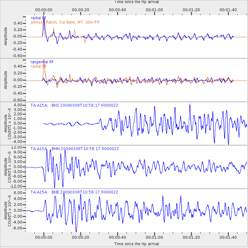
Signal To Noise
| Channel | StoN | STA | LTA |
| TA:A15A: :BHN:20090306T10:58:17.600002Z | 38.454777 | 5.724719E-6 | 1.4886885E-7 |
| TA:A15A: :BHE:20090306T10:58:17.600002Z | 11.243808 | 2.2380348E-6 | 1.99046E-7 |
| TA:A15A: :BHZ:20090306T10:58:17.600002Z | 3.9739308 | 7.288941E-7 | 1.8341892E-7 |
| Arrivals |
| Ps | 8.9 SECOND |
| PpPs | 28 SECOND |
| PsPs/PpSs | 37 SECOND |


