You are here: Home > Network List > TA - USArray Transportable Network (new EarthScope stations) Stations List
> Station A15A Johnson Ranch, Cut Bank, MT, USA > Earthquake Result Viewer
A15A Johnson Ranch, Cut Bank, MT, USA - Earthquake Result Viewer
| Earthquake location: |
Crete, Greece |
| Earthquake latitude/longitude: |
34.2/25.5 |
| Earthquake time(UTC): |
2009/07/01 (182) 09:30:10 GMT |
| Earthquake Depth: |
19 km |
| Earthquake Magnitude: |
6.1 MB, 6.3 MS, 6.4 MW, 6.4 MW |
| Earthquake Catalog/Contributor: |
WHDF/NEIC |
|
| Network: |
TA USArray Transportable Network (new EarthScope stations) |
| Station: |
A15A Johnson Ranch, Cut Bank, MT, USA |
| Lat/Lon: |
48.98 N/112.73 W |
| Elevation: |
1236 m |
|
| Distance: |
89.2 deg |
| Az: |
333.95 deg |
| Baz: |
33.551 deg |
| Ray Param: |
0.041977536 |
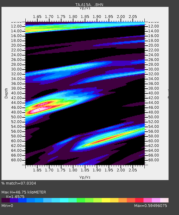
| Estimated Moho Depth: |
46.75 km |
| Estimated Crust Vp/Vs: |
1.66 |
| Assumed Crust Vp: |
6.178 km/s |
| Estimated Crust Vs: |
3.727 km/s |
| Estimated Crust Poisson's Ratio: |
0.21 |
|
| Radial Match: |
87.8304 % |
| Radial Bump: |
400 |
| Transverse Match: |
69.01502 % |
| Transverse Bump: |
400 |
| SOD ConfigId: |
2648 |
| Insert Time: |
2010-03-06 18:33:03.600 +0000 |
| GWidth: |
2.5 |
| Max Bumps: |
400 |
| Tol: |
0.001 |
|

Signal To Noise
| Channel | StoN | STA | LTA |
| TA:A15A: :BHN:20090701T09:42:33.524014Z | 4.3815975 | 3.6777863E-7 | 8.39371E-8 |
| TA:A15A: :BHE:20090701T09:42:33.524014Z | 1.2070488 | 1.3492416E-7 | 1.1178022E-7 |
| TA:A15A: :BHZ:20090701T09:42:33.524014Z | 1.6266617 | 1.4247784E-7 | 8.758911E-8 |
| Arrivals |
| Ps | 5.1 SECOND |
| PpPs | 20 SECOND |
| PsPs/PpSs | 25 SECOND |


