You are here: Home > Network List > TA - USArray Transportable Network (new EarthScope stations) Stations List
> Station A15A Johnson Ranch, Cut Bank, MT, USA > Earthquake Result Viewer
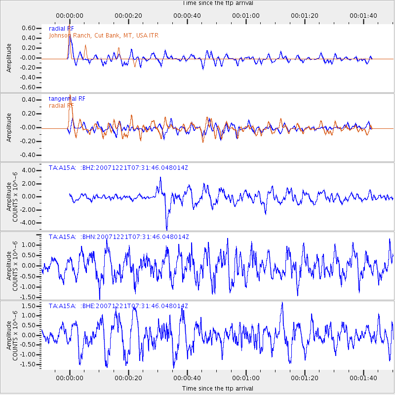
A15A Johnson Ranch, Cut Bank, MT, USA - Earthquake Result Viewer

| Earthquake location: |
Andreanof Islands, Aleutian Is. |
| Earthquake latitude/longitude: |
51.4/-179.0 |
| Earthquake time(UTC): |
2007/12/21 (355) 07:24:34 GMT |
| Earthquake Depth: |
30 km |
| Earthquake Magnitude: |
6.1 MB, 6.2 MW, 6.3 ML |
| Earthquake Catalog/Contributor: |
WHDF/NEIC |
|
| Network: |
TA USArray Transportable Network (new EarthScope stations) |
| Station: |
A15A Johnson Ranch, Cut Bank, MT, USA |
| Lat/Lon: |
48.98 N/112.73 W |
| Elevation: |
1236 m |
|
| Distance: |
41.2 deg |
| Az: |
66.285 deg |
| Baz: |
299.392 deg |
| Ray Param: |
0.073885545 |
| Estimated Moho Depth: |
18.75 km |
| Estimated Crust Vp/Vs: |
2.09 |
| Assumed Crust Vp: |
6.178 km/s |
| Estimated Crust Vs: |
2.956 km/s |
| Estimated Crust Poisson's Ratio: |
0.35 |
|
| Radial Match: |
83.446556 % |
| Radial Bump: |
400 |
| Transverse Match: |
74.11849 % |
| Transverse Bump: |
400 |
| SOD ConfigId: |
2564 |
| Insert Time: |
2010-03-06 18:33:17.529 +0000 |
| GWidth: |
2.5 |
| Max Bumps: |
400 |
| Tol: |
0.001 |
|
Signal To Noise
| Channel | StoN | STA | LTA |
| TA:A15A: :BHN:20071221T07:31:46.048014Z | 1.7430513 | 4.6145098E-7 | 2.6473745E-7 |
| TA:A15A: :BHE:20071221T07:31:46.048014Z | 1.890641 | 6.977604E-7 | 3.6906025E-7 |
| TA:A15A: :BHZ:20071221T07:31:46.048014Z | 6.841053 | 2.058907E-6 | 3.0096348E-7 |
| Arrivals |
| Ps | 3.5 SECOND |
| PpPs | 8.9 SECOND |
| PsPs/PpSs | 12 SECOND |


