You are here: Home > Network List > TA - USArray Transportable Network (new EarthScope stations) Stations List
> Station O17K Koliganek, Bristol Bay, AK, USA > Earthquake Result Viewer
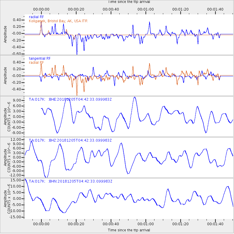
O17K Koliganek, Bristol Bay, AK, USA - Earthquake Result Viewer
*The percent match for this event was below the threshold and hence no stack was calculated.
| Earthquake location: |
Southeast Of Loyalty Islands |
| Earthquake latitude/longitude: |
-21.8/169.1 |
| Earthquake time(UTC): |
2018/12/05 (339) 04:30:24 GMT |
| Earthquake Depth: |
10 km |
| Earthquake Magnitude: |
5.9 mb |
| Earthquake Catalog/Contributor: |
NEIC PDE/us |
|
| Network: |
TA USArray Transportable Network (new EarthScope stations) |
| Station: |
O17K Koliganek, Bristol Bay, AK, USA |
| Lat/Lon: |
59.77 N/157.09 W |
| Elevation: |
156 m |
|
| Distance: |
85.9 deg |
| Az: |
16.39 deg |
| Baz: |
211.21 deg |
| Ray Param: |
$rayparam |
*The percent match for this event was below the threshold and hence was not used in the summary stack. |
|
| Radial Match: |
54.343353 % |
| Radial Bump: |
387 |
| Transverse Match: |
42.67183 % |
| Transverse Bump: |
286 |
| SOD ConfigId: |
13570011 |
| Insert Time: |
2019-05-02 00:33:16.010 +0000 |
| GWidth: |
2.5 |
| Max Bumps: |
400 |
| Tol: |
0.001 |
|
Signal To Noise
| Channel | StoN | STA | LTA |
| TA:O17K: :BHZ:20181205T04:42:33.099983Z | 2.9863925 | 1.0591832E-5 | 3.5466978E-6 |
| TA:O17K: :BHN:20181205T04:42:33.099983Z | 1.5045447 | 1.0560421E-5 | 7.0190144E-6 |
| TA:O17K: :BHE:20181205T04:42:33.099983Z | 1.460468 | 7.17993E-6 | 4.9161845E-6 |
| Arrivals |
| Ps | |
| PpPs | |
| PsPs/PpSs | |


