You are here: Home > Network List > TA - USArray Transportable Network (new EarthScope stations) Stations List
> Station Q17K Contact Creek, Katmai, AK, USA > Earthquake Result Viewer
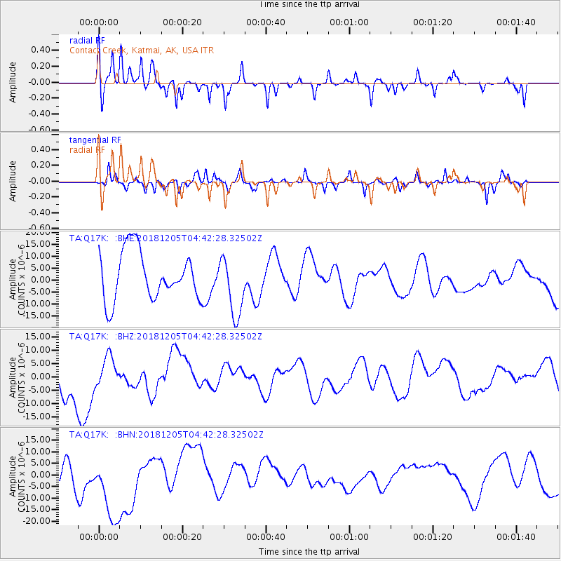
Q17K Contact Creek, Katmai, AK, USA - Earthquake Result Viewer
*The percent match for this event was below the threshold and hence no stack was calculated.
| Earthquake location: |
Southeast Of Loyalty Islands |
| Earthquake latitude/longitude: |
-21.8/169.1 |
| Earthquake time(UTC): |
2018/12/05 (339) 04:30:24 GMT |
| Earthquake Depth: |
10 km |
| Earthquake Magnitude: |
5.9 mb |
| Earthquake Catalog/Contributor: |
NEIC PDE/us |
|
| Network: |
TA USArray Transportable Network (new EarthScope stations) |
| Station: |
Q17K Contact Creek, Katmai, AK, USA |
| Lat/Lon: |
58.26 N/155.89 W |
| Elevation: |
1165 m |
|
| Distance: |
84.9 deg |
| Az: |
17.723 deg |
| Baz: |
212.35 deg |
| Ray Param: |
$rayparam |
*The percent match for this event was below the threshold and hence was not used in the summary stack. |
|
| Radial Match: |
42.741615 % |
| Radial Bump: |
207 |
| Transverse Match: |
50.791607 % |
| Transverse Bump: |
293 |
| SOD ConfigId: |
13570011 |
| Insert Time: |
2019-05-02 00:33:20.718 +0000 |
| GWidth: |
2.5 |
| Max Bumps: |
400 |
| Tol: |
0.001 |
|
Signal To Noise
| Channel | StoN | STA | LTA |
| TA:Q17K: :BHZ:20181205T04:42:28.32502Z | 0.53068113 | 5.0317894E-6 | 9.481757E-6 |
| TA:Q17K: :BHN:20181205T04:42:28.32502Z | 2.128973 | 1.7879609E-5 | 8.398232E-6 |
| TA:Q17K: :BHE:20181205T04:42:28.32502Z | 1.2813991 | 1.3023902E-5 | 1.0163813E-5 |
| Arrivals |
| Ps | |
| PpPs | |
| PsPs/PpSs | |


