You are here: Home > Network List > TA - USArray Transportable Network (new EarthScope stations) Stations List
> Station A15A Johnson Ranch, Cut Bank, MT, USA > Earthquake Result Viewer
A15A Johnson Ranch, Cut Bank, MT, USA - Earthquake Result Viewer
| Earthquake location: |
Andreanof Islands, Aleutian Is. |
| Earthquake latitude/longitude: |
51.9/-179.2 |
| Earthquake time(UTC): |
2008/04/16 (107) 05:54:19 GMT |
| Earthquake Depth: |
13 km |
| Earthquake Magnitude: |
6.1 MB, 6.5 MS, 6.6 MW, 6.6 MW |
| Earthquake Catalog/Contributor: |
WHDF/NEIC |
|
| Network: |
TA USArray Transportable Network (new EarthScope stations) |
| Station: |
A15A Johnson Ranch, Cut Bank, MT, USA |
| Lat/Lon: |
48.98 N/112.73 W |
| Elevation: |
1236 m |
|
| Distance: |
41.1 deg |
| Az: |
66.737 deg |
| Baz: |
300.188 deg |
| Ray Param: |
0.073997155 |
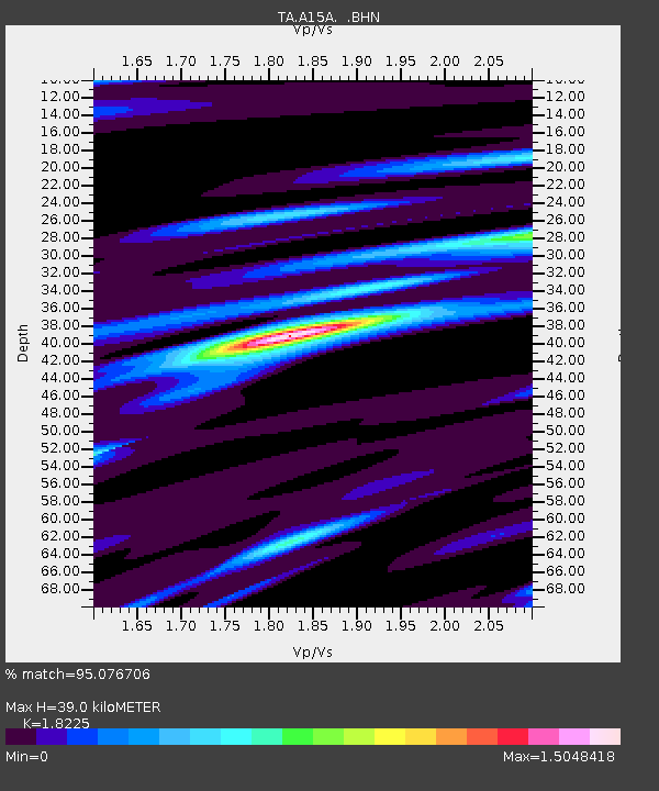
| Estimated Moho Depth: |
39.0 km |
| Estimated Crust Vp/Vs: |
1.82 |
| Assumed Crust Vp: |
6.178 km/s |
| Estimated Crust Vs: |
3.39 km/s |
| Estimated Crust Poisson's Ratio: |
0.28 |
|
| Radial Match: |
95.076706 % |
| Radial Bump: |
350 |
| Transverse Match: |
74.17485 % |
| Transverse Bump: |
400 |
| SOD ConfigId: |
2504 |
| Insert Time: |
2010-03-06 18:33:39.369 +0000 |
| GWidth: |
2.5 |
| Max Bumps: |
400 |
| Tol: |
0.001 |
|

Signal To Noise
| Channel | StoN | STA | LTA |
| TA:A15A: :BHN:20080416T06:01:32.24899Z | 4.9157524 | 6.1906206E-7 | 1.2593435E-7 |
| TA:A15A: :BHE:20080416T06:01:32.24899Z | 1.6792384 | 2.0298022E-7 | 1.2087635E-7 |
| TA:A15A: :BHZ:20080416T06:01:32.24899Z | 2.6437538 | 3.8909934E-7 | 1.4717685E-7 |
| Arrivals |
| Ps | 5.5 SECOND |
| PpPs | 17 SECOND |
| PsPs/PpSs | 22 SECOND |


