You are here: Home > Network List > PF - Volcanologic Network of Piton de Fournaise-OVPF Stations List
> Station HDL Station Sismologique de Hubert Delisle > Earthquake Result Viewer
HDL Station Sismologique de Hubert Delisle - Earthquake Result Viewer
| Earthquake location: |
Myanmar |
| Earthquake latitude/longitude: |
20.9/94.6 |
| Earthquake time(UTC): |
2016/08/24 (237) 10:34:55 GMT |
| Earthquake Depth: |
84 km |
| Earthquake Magnitude: |
6.8 MO |
| Earthquake Catalog/Contributor: |
NEIC PDE/NEIC ALERT |
|
| Network: |
PF Volcanologic Network of Piton de Fournaise-OVPF |
| Station: |
HDL Station Sismologique de Hubert Delisle |
| Lat/Lon: |
21.25 S/55.79 E |
| Elevation: |
242 m |
|
| Distance: |
56.5 deg |
| Az: |
224.485 deg |
| Baz: |
44.609 deg |
| Ray Param: |
0.06385615 |
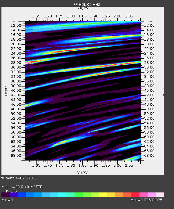
| Estimated Moho Depth: |
28.0 km |
| Estimated Crust Vp/Vs: |
1.60 |
| Assumed Crust Vp: |
4.73 km/s |
| Estimated Crust Vs: |
2.956 km/s |
| Estimated Crust Poisson's Ratio: |
0.18 |
|
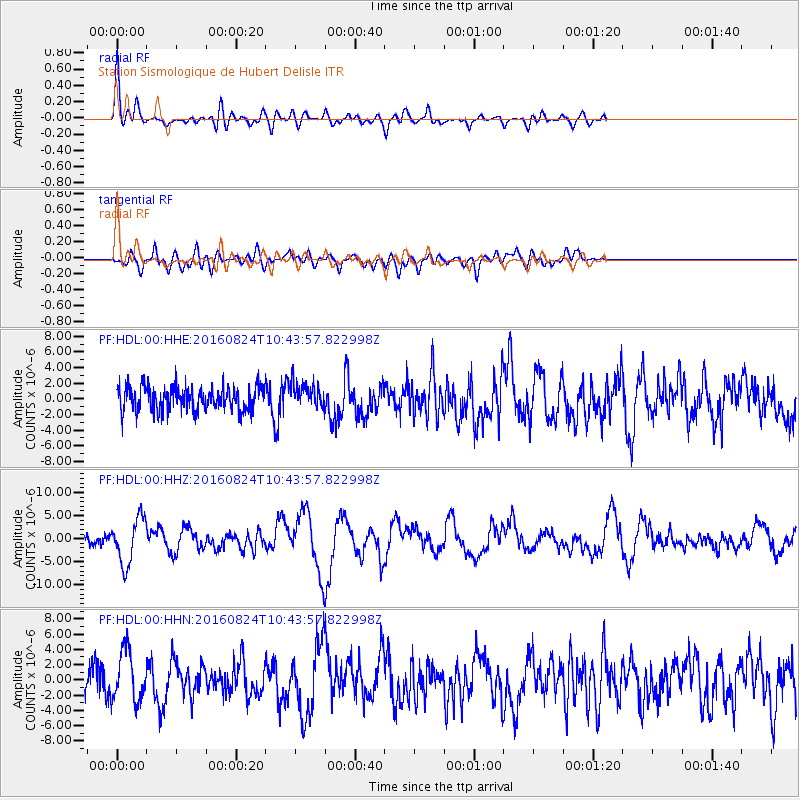
| Radial Match: |
82.57811 % |
| Radial Bump: |
400 |
| Transverse Match: |
60.276188 % |
| Transverse Bump: |
400 |
| SOD ConfigId: |
1634031 |
| Insert Time: |
2016-09-07 10:38:25.158 +0000 |
| GWidth: |
2.5 |
| Max Bumps: |
400 |
| Tol: |
0.001 |
|
Signal To Noise
| Channel | StoN | STA | LTA |
| PF:HDL:00:HHZ:20160824T10:43:57.822998Z | 5.1790285 | 4.9084438E-6 | 9.477537E-7 |
| PF:HDL:00:HHN:20160824T10:43:57.822998Z | 2.195278 | 3.3762083E-6 | 1.5379412E-6 |
| PF:HDL:00:HHE:20160824T10:43:57.822998Z | 0.98808604 | 1.4901457E-6 | 1.5081132E-6 |
| Arrivals |
| Ps | 3.7 SECOND |
| PpPs | 15 SECOND |
| PsPs/PpSs | 19 SECOND |


