You are here: Home > Network List > PF - Volcanologic Network of Piton de Fournaise-OVPF Stations List
> Station HIM cratere Himiltrude > Earthquake Result Viewer
HIM cratere Himiltrude - Earthquake Result Viewer
| Earthquake location: |
Myanmar |
| Earthquake latitude/longitude: |
20.9/94.6 |
| Earthquake time(UTC): |
2016/08/24 (237) 10:34:55 GMT |
| Earthquake Depth: |
84 km |
| Earthquake Magnitude: |
6.8 MO |
| Earthquake Catalog/Contributor: |
NEIC PDE/NEIC ALERT |
|
| Network: |
PF Volcanologic Network of Piton de Fournaise-OVPF |
| Station: |
HIM cratere Himiltrude |
| Lat/Lon: |
21.21 S/55.72 E |
| Elevation: |
1958 m |
|
| Distance: |
56.5 deg |
| Az: |
224.574 deg |
| Baz: |
44.684 deg |
| Ray Param: |
0.063844316 |
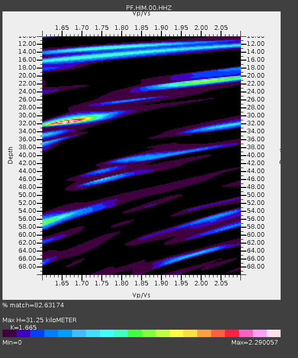
| Estimated Moho Depth: |
31.25 km |
| Estimated Crust Vp/Vs: |
1.66 |
| Assumed Crust Vp: |
4.73 km/s |
| Estimated Crust Vs: |
2.841 km/s |
| Estimated Crust Poisson's Ratio: |
0.22 |
|
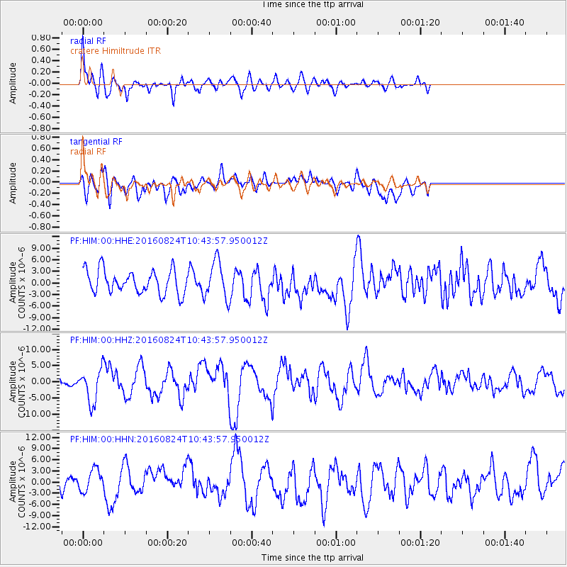
| Radial Match: |
82.63174 % |
| Radial Bump: |
400 |
| Transverse Match: |
46.37727 % |
| Transverse Bump: |
400 |
| SOD ConfigId: |
1634031 |
| Insert Time: |
2016-09-07 10:38:26.353 +0000 |
| GWidth: |
2.5 |
| Max Bumps: |
400 |
| Tol: |
0.001 |
|
Signal To Noise
| Channel | StoN | STA | LTA |
| PF:HIM:00:HHZ:20160824T10:43:57.950012Z | 4.4668946 | 5.2429264E-6 | 1.1737296E-6 |
| PF:HIM:00:HHN:20160824T10:43:57.950012Z | 1.7237003 | 3.244405E-6 | 1.8822327E-6 |
| PF:HIM:00:HHE:20160824T10:43:57.950012Z | 1.6544629 | 4.945156E-6 | 2.9889795E-6 |
| Arrivals |
| Ps | 4.5 SECOND |
| PpPs | 17 SECOND |
| PsPs/PpSs | 22 SECOND |


