You are here: Home > Network List > CI - Caltech Regional Seismic Network Stations List
> Station FUR Furnace Creek, CA, USA > Earthquake Result Viewer
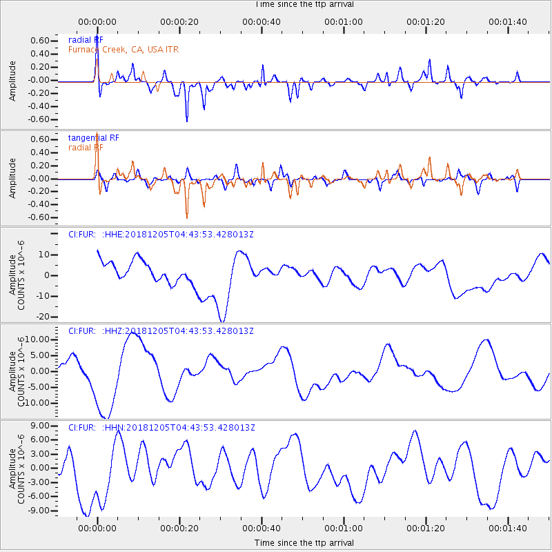
FUR Furnace Creek, CA, USA - Earthquake Result Viewer
*The percent match for this event was below the threshold and hence no stack was calculated.
| Earthquake location: |
Southeast Of Loyalty Islands |
| Earthquake latitude/longitude: |
-21.9/169.5 |
| Earthquake time(UTC): |
2018/12/05 (339) 04:31:23 GMT |
| Earthquake Depth: |
10 km |
| Earthquake Magnitude: |
5.6 mb |
| Earthquake Catalog/Contributor: |
NEIC PDE/us |
|
| Network: |
CI Caltech Regional Seismic Network |
| Station: |
FUR Furnace Creek, CA, USA |
| Lat/Lon: |
36.47 N/116.86 W |
| Elevation: |
-37.0 m |
|
| Distance: |
90.4 deg |
| Az: |
50.652 deg |
| Baz: |
243.005 deg |
| Ray Param: |
$rayparam |
*The percent match for this event was below the threshold and hence was not used in the summary stack. |
|
| Radial Match: |
61.252792 % |
| Radial Bump: |
400 |
| Transverse Match: |
47.504795 % |
| Transverse Bump: |
400 |
| SOD ConfigId: |
13570011 |
| Insert Time: |
2019-05-02 00:37:13.077 +0000 |
| GWidth: |
2.5 |
| Max Bumps: |
400 |
| Tol: |
0.001 |
|
Signal To Noise
| Channel | StoN | STA | LTA |
| CI:FUR: :HHZ:20181205T04:43:53.428013Z | 1.5169705 | 1.2557258E-5 | 8.277852E-6 |
| CI:FUR: :HHN:20181205T04:43:53.428013Z | 2.1896904 | 6.8776567E-6 | 3.1409265E-6 |
| CI:FUR: :HHE:20181205T04:43:53.428013Z | 3.038416 | 1.5511165E-5 | 5.105017E-6 |
| Arrivals |
| Ps | |
| PpPs | |
| PsPs/PpSs | |


