You are here: Home > Network List > TA - USArray Transportable Network (new EarthScope stations) Stations List
> Station G31M Satah River, YT, CAN > Earthquake Result Viewer
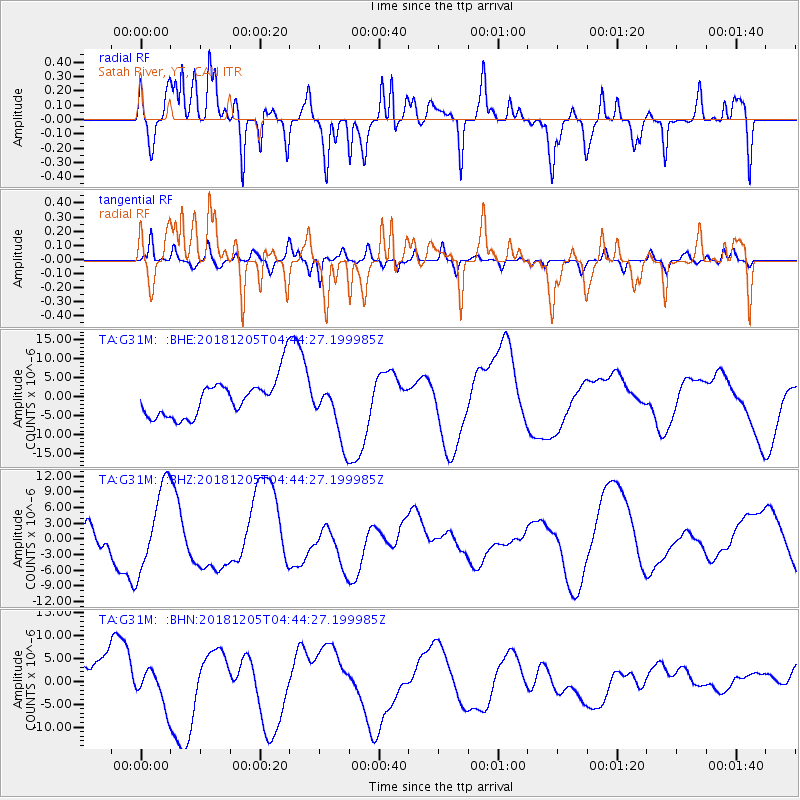
G31M Satah River, YT, CAN - Earthquake Result Viewer
*The percent match for this event was below the threshold and hence no stack was calculated.
| Earthquake location: |
Southeast Of Loyalty Islands |
| Earthquake latitude/longitude: |
-21.9/169.5 |
| Earthquake time(UTC): |
2018/12/05 (339) 04:31:23 GMT |
| Earthquake Depth: |
10 km |
| Earthquake Magnitude: |
5.6 mb |
| Earthquake Catalog/Contributor: |
NEIC PDE/us |
|
| Network: |
TA USArray Transportable Network (new EarthScope stations) |
| Station: |
G31M Satah River, YT, CAN |
| Lat/Lon: |
66.92 N/134.27 W |
| Elevation: |
61 m |
|
| Distance: |
97.9 deg |
| Az: |
19.308 deg |
| Baz: |
231.174 deg |
| Ray Param: |
$rayparam |
*The percent match for this event was below the threshold and hence was not used in the summary stack. |
|
| Radial Match: |
51.251934 % |
| Radial Bump: |
351 |
| Transverse Match: |
58.24131 % |
| Transverse Bump: |
400 |
| SOD ConfigId: |
13570011 |
| Insert Time: |
2019-05-02 00:39:48.021 +0000 |
| GWidth: |
2.5 |
| Max Bumps: |
400 |
| Tol: |
0.001 |
|
Signal To Noise
| Channel | StoN | STA | LTA |
| TA:G31M: :BHZ:20181205T04:44:27.199985Z | 2.3942974 | 8.0860145E-6 | 3.3771971E-6 |
| TA:G31M: :BHN:20181205T04:44:27.199985Z | 1.1271234 | 3.7955406E-6 | 3.367458E-6 |
| TA:G31M: :BHE:20181205T04:44:27.199985Z | 1.5411831 | 7.695186E-6 | 4.9930377E-6 |
| Arrivals |
| Ps | |
| PpPs | |
| PsPs/PpSs | |


