You are here: Home > Network List > TA - USArray Transportable Network (new EarthScope stations) Stations List
> Station A15A Johnson Ranch, Cut Bank, MT, USA > Earthquake Result Viewer
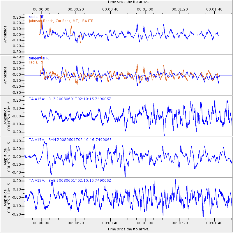
A15A Johnson Ranch, Cut Bank, MT, USA - Earthquake Result Viewer
*The percent match for this event was below the threshold and hence no stack was calculated.
| Earthquake location: |
Philippine Islands Region |
| Earthquake latitude/longitude: |
20.1/121.4 |
| Earthquake time(UTC): |
2008/06/01 (153) 01:57:24 GMT |
| Earthquake Depth: |
35 km |
| Earthquake Magnitude: |
6.0 MB, 6.2 MS, 6.3 MW, 6.2 MW |
| Earthquake Catalog/Contributor: |
WHDF/NEIC |
|
| Network: |
TA USArray Transportable Network (new EarthScope stations) |
| Station: |
A15A Johnson Ranch, Cut Bank, MT, USA |
| Lat/Lon: |
48.98 N/112.73 W |
| Elevation: |
1236 m |
|
| Distance: |
96.1 deg |
| Az: |
32.461 deg |
| Baz: |
310.05 deg |
| Ray Param: |
$rayparam |
*The percent match for this event was below the threshold and hence was not used in the summary stack. |
|
| Radial Match: |
69.93119 % |
| Radial Bump: |
400 |
| Transverse Match: |
58.24636 % |
| Transverse Bump: |
400 |
| SOD ConfigId: |
2504 |
| Insert Time: |
2010-03-06 18:34:15.749 +0000 |
| GWidth: |
2.5 |
| Max Bumps: |
400 |
| Tol: |
0.001 |
|
Signal To Noise
| Channel | StoN | STA | LTA |
| TA:A15A: :BHN:20080601T02:10:16.749006Z | 4.6510644 | 2.3233899E-7 | 4.995394E-8 |
| TA:A15A: :BHE:20080601T02:10:16.749006Z | 1.6726536 | 8.6034156E-8 | 5.143573E-8 |
| TA:A15A: :BHZ:20080601T02:10:16.749006Z | 1.1170043 | 4.3603062E-8 | 3.9035715E-8 |
| Arrivals |
| Ps | |
| PpPs | |
| PsPs/PpSs | |


