You are here: Home > Network List > CI - Caltech Regional Seismic Network Stations List
> Station LRL Laurel Mtn Radio Fac, Ridgecrest, CA, USA > Earthquake Result Viewer
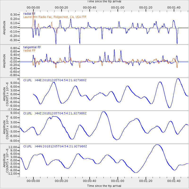
LRL Laurel Mtn Radio Fac, Ridgecrest, CA, USA - Earthquake Result Viewer
*The percent match for this event was below the threshold and hence no stack was calculated.
| Earthquake location: |
Southeast Of Loyalty Islands |
| Earthquake latitude/longitude: |
-21.7/169.2 |
| Earthquake time(UTC): |
2018/12/05 (339) 04:41:56 GMT |
| Earthquake Depth: |
10 km |
| Earthquake Magnitude: |
5.7 mb |
| Earthquake Catalog/Contributor: |
NEIC PDE/us |
|
| Network: |
CI Caltech Regional Seismic Network |
| Station: |
LRL Laurel Mtn Radio Fac, Ridgecrest, CA, USA |
| Lat/Lon: |
35.48 N/117.68 W |
| Elevation: |
1340 m |
|
| Distance: |
89.5 deg |
| Az: |
51.338 deg |
| Baz: |
242.841 deg |
| Ray Param: |
$rayparam |
*The percent match for this event was below the threshold and hence was not used in the summary stack. |
|
| Radial Match: |
41.34729 % |
| Radial Bump: |
367 |
| Transverse Match: |
86.08584 % |
| Transverse Bump: |
307 |
| SOD ConfigId: |
13570011 |
| Insert Time: |
2019-05-02 00:43:38.856 +0000 |
| GWidth: |
2.5 |
| Max Bumps: |
400 |
| Tol: |
0.001 |
|
Signal To Noise
| Channel | StoN | STA | LTA |
| CI:LRL: :HHZ:20181205T04:54:21.927986Z | 2.0850525 | 3.0604058E-6 | 1.4677836E-6 |
| CI:LRL: :HHN:20181205T04:54:21.927986Z | 1.9322449 | 6.128569E-6 | 3.171735E-6 |
| CI:LRL: :HHE:20181205T04:54:21.927986Z | 0.9875525 | 5.103557E-6 | 5.1678844E-6 |
| Arrivals |
| Ps | |
| PpPs | |
| PsPs/PpSs | |


