You are here: Home > Network List > TA - USArray Transportable Network (new EarthScope stations) Stations List
> Station A15A Johnson Ranch, Cut Bank, MT, USA > Earthquake Result Viewer
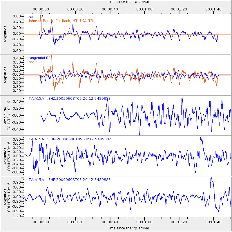
A15A Johnson Ranch, Cut Bank, MT, USA - Earthquake Result Viewer
*The percent match for this event was below the threshold and hence no stack was calculated.
| Earthquake location: |
Honduras |
| Earthquake latitude/longitude: |
15.8/-86.9 |
| Earthquake time(UTC): |
2009/06/08 (159) 05:13:14 GMT |
| Earthquake Depth: |
10 km |
| Earthquake Magnitude: |
5.5 MB, 4.9 MS, 5.4 MW, 5.4 MW |
| Earthquake Catalog/Contributor: |
WHDF/NEIC |
|
| Network: |
TA USArray Transportable Network (new EarthScope stations) |
| Station: |
A15A Johnson Ranch, Cut Bank, MT, USA |
| Lat/Lon: |
48.98 N/112.73 W |
| Elevation: |
1236 m |
|
| Distance: |
39.3 deg |
| Az: |
332.989 deg |
| Baz: |
138.423 deg |
| Ray Param: |
$rayparam |
*The percent match for this event was below the threshold and hence was not used in the summary stack. |
|
| Radial Match: |
61.989235 % |
| Radial Bump: |
400 |
| Transverse Match: |
50.812107 % |
| Transverse Bump: |
400 |
| SOD ConfigId: |
2648 |
| Insert Time: |
2010-03-06 18:34:59.314 +0000 |
| GWidth: |
2.5 |
| Max Bumps: |
400 |
| Tol: |
0.001 |
|
Signal To Noise
| Channel | StoN | STA | LTA |
| TA:A15A: :BHN:20090608T05:20:12.548988Z | 3.6323986 | 3.934291E-7 | 1.083111E-7 |
| TA:A15A: :BHE:20090608T05:20:12.548988Z | 3.3081222 | 3.249541E-7 | 9.822917E-8 |
| TA:A15A: :BHZ:20090608T05:20:12.548988Z | 1.5127493 | 1.354787E-7 | 8.9557936E-8 |
| Arrivals |
| Ps | |
| PpPs | |
| PsPs/PpSs | |


