You are here: Home > Network List > CB - China National Seismic Network Stations List
> Station HHC Huhehaote,Neimeng Province > Earthquake Result Viewer
HHC Huhehaote,Neimeng Province - Earthquake Result Viewer
| Earthquake location: |
Southeast Of Loyalty Islands |
| Earthquake latitude/longitude: |
-22.1/169.7 |
| Earthquake time(UTC): |
2018/12/05 (339) 06:43:04 GMT |
| Earthquake Depth: |
10 km |
| Earthquake Magnitude: |
6.6 Mww |
| Earthquake Catalog/Contributor: |
NEIC PDE/us |
|
| Network: |
CB China National Seismic Network |
| Station: |
HHC Huhehaote,Neimeng Province |
| Lat/Lon: |
40.85 N/111.56 E |
| Elevation: |
1169 m |
|
| Distance: |
82.6 deg |
| Az: |
319.5 deg |
| Baz: |
127.416 deg |
| Ray Param: |
0.046769347 |
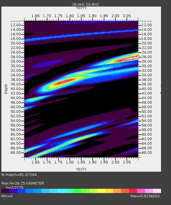
| Estimated Moho Depth: |
26.25 km |
| Estimated Crust Vp/Vs: |
2.08 |
| Assumed Crust Vp: |
6.384 km/s |
| Estimated Crust Vs: |
3.073 km/s |
| Estimated Crust Poisson's Ratio: |
0.35 |
|
| Radial Match: |
91.87264 % |
| Radial Bump: |
299 |
| Transverse Match: |
63.676525 % |
| Transverse Bump: |
400 |
| SOD ConfigId: |
13570011 |
| Insert Time: |
2019-05-02 00:49:12.234 +0000 |
| GWidth: |
2.5 |
| Max Bumps: |
400 |
| Tol: |
0.001 |
|

Signal To Noise
| Channel | StoN | STA | LTA |
| CB:HHC:00:BHZ:20181205T06:54:55.919988Z | 1.3775188 | 1.2781801E-6 | 9.2788576E-7 |
| CB:HHC:00:BHN:20181205T06:54:55.919988Z | 2.3198707 | 1.8945693E-6 | 8.1667025E-7 |
| CB:HHC:00:BHE:20181205T06:54:55.919988Z | 2.5261233 | 1.9953766E-6 | 7.898968E-7 |
| Arrivals |
| Ps | 4.5 SECOND |
| PpPs | 12 SECOND |
| PsPs/PpSs | 17 SECOND |


