You are here: Home > Network List > CN - Canadian National Seismograph Network Stations List
> Station GRNB Grenville Island, BC, CA > Earthquake Result Viewer
GRNB Grenville Island, BC, CA - Earthquake Result Viewer
| Earthquake location: |
Southeast Of Loyalty Islands |
| Earthquake latitude/longitude: |
-22.1/169.7 |
| Earthquake time(UTC): |
2018/12/05 (339) 06:43:04 GMT |
| Earthquake Depth: |
10 km |
| Earthquake Magnitude: |
6.6 Mww |
| Earthquake Catalog/Contributor: |
NEIC PDE/us |
|
| Network: |
CN Canadian National Seismograph Network |
| Station: |
GRNB Grenville Island, BC, CA |
| Lat/Lon: |
53.85 N/129.96 W |
| Elevation: |
461 m |
|
| Distance: |
91.7 deg |
| Az: |
31.017 deg |
| Baz: |
233.784 deg |
| Ray Param: |
0.04157632 |
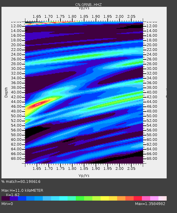
| Estimated Moho Depth: |
11.0 km |
| Estimated Crust Vp/Vs: |
1.62 |
| Assumed Crust Vp: |
6.545 km/s |
| Estimated Crust Vs: |
4.04 km/s |
| Estimated Crust Poisson's Ratio: |
0.19 |
|
| Radial Match: |
80.198616 % |
| Radial Bump: |
400 |
| Transverse Match: |
89.4107 % |
| Transverse Bump: |
400 |
| SOD ConfigId: |
13570011 |
| Insert Time: |
2019-05-02 00:49:53.043 +0000 |
| GWidth: |
2.5 |
| Max Bumps: |
400 |
| Tol: |
0.001 |
|

Signal To Noise
| Channel | StoN | STA | LTA |
| CN:GRNB: :HHZ:20181205T06:55:39.807988Z | 1.0270008 | 1.8634498E-6 | 1.8144581E-6 |
| CN:GRNB: :HHN:20181205T06:55:39.807988Z | 0.9377921 | 9.403765E-7 | 1.0027558E-6 |
| CN:GRNB: :HHE:20181205T06:55:39.807988Z | 2.5212786 | 3.0191486E-6 | 1.1974672E-6 |
| Arrivals |
| Ps | 1.1 SECOND |
| PpPs | 4.3 SECOND |
| PsPs/PpSs | 5.4 SECOND |


