You are here: Home > Network List > TA - USArray Transportable Network (new EarthScope stations) Stations List
> Station G21K Allakaket, AK, USA > Earthquake Result Viewer
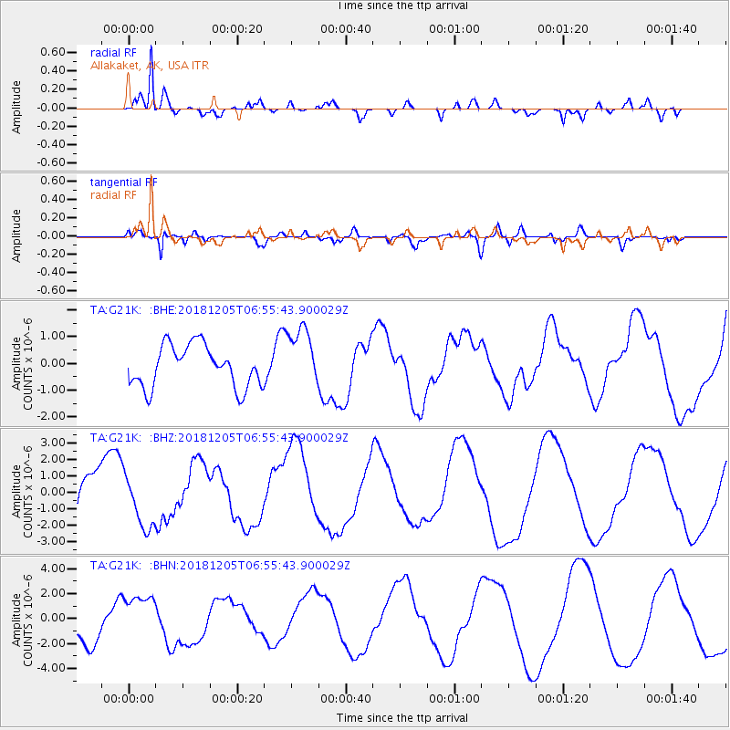
G21K Allakaket, AK, USA - Earthquake Result Viewer
*The percent match for this event was below the threshold and hence no stack was calculated.
| Earthquake location: |
Southeast Of Loyalty Islands |
| Earthquake latitude/longitude: |
-22.1/169.7 |
| Earthquake time(UTC): |
2018/12/05 (339) 06:43:04 GMT |
| Earthquake Depth: |
10 km |
| Earthquake Magnitude: |
6.6 Mww |
| Earthquake Catalog/Contributor: |
NEIC PDE/us |
|
| Network: |
TA USArray Transportable Network (new EarthScope stations) |
| Station: |
G21K Allakaket, AK, USA |
| Lat/Lon: |
66.52 N/153.51 W |
| Elevation: |
446 m |
|
| Distance: |
92.5 deg |
| Az: |
13.913 deg |
| Baz: |
213.823 deg |
| Ray Param: |
$rayparam |
*The percent match for this event was below the threshold and hence was not used in the summary stack. |
|
| Radial Match: |
95.555016 % |
| Radial Bump: |
276 |
| Transverse Match: |
76.50078 % |
| Transverse Bump: |
400 |
| SOD ConfigId: |
13570011 |
| Insert Time: |
2019-05-02 00:51:24.398 +0000 |
| GWidth: |
2.5 |
| Max Bumps: |
400 |
| Tol: |
0.001 |
|
Signal To Noise
| Channel | StoN | STA | LTA |
| TA:G21K: :BHZ:20181205T06:55:43.900029Z | 1.1092948 | 1.6425314E-6 | 1.4806989E-6 |
| TA:G21K: :BHN:20181205T06:55:43.900029Z | 1.2443408 | 1.9501742E-6 | 1.5672347E-6 |
| TA:G21K: :BHE:20181205T06:55:43.900029Z | 1.4720079 | 1.1366149E-6 | 7.7215276E-7 |
| Arrivals |
| Ps | |
| PpPs | |
| PsPs/PpSs | |


