You are here: Home > Network List > TA - USArray Transportable Network (new EarthScope stations) Stations List
> Station S22A 4UR Ranch, Creede, CO, USA > Earthquake Result Viewer
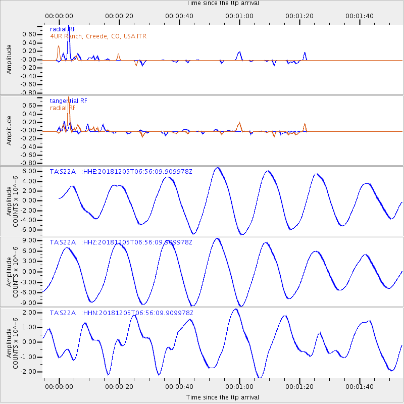
S22A 4UR Ranch, Creede, CO, USA - Earthquake Result Viewer
*The percent match for this event was below the threshold and hence no stack was calculated.
| Earthquake location: |
Southeast Of Loyalty Islands |
| Earthquake latitude/longitude: |
-22.1/169.7 |
| Earthquake time(UTC): |
2018/12/05 (339) 06:43:04 GMT |
| Earthquake Depth: |
10 km |
| Earthquake Magnitude: |
6.6 Mww |
| Earthquake Catalog/Contributor: |
NEIC PDE/us |
|
| Network: |
TA USArray Transportable Network (new EarthScope stations) |
| Station: |
S22A 4UR Ranch, Creede, CO, USA |
| Lat/Lon: |
37.75 N/106.83 W |
| Elevation: |
2626 m |
|
| Distance: |
98.3 deg |
| Az: |
52.746 deg |
| Baz: |
248.673 deg |
| Ray Param: |
$rayparam |
*The percent match for this event was below the threshold and hence was not used in the summary stack. |
|
| Radial Match: |
92.599724 % |
| Radial Bump: |
310 |
| Transverse Match: |
84.746254 % |
| Transverse Bump: |
400 |
| SOD ConfigId: |
13570011 |
| Insert Time: |
2019-05-02 00:51:55.236 +0000 |
| GWidth: |
2.5 |
| Max Bumps: |
400 |
| Tol: |
0.001 |
|
Signal To Noise
| Channel | StoN | STA | LTA |
| TA:S22A: :HHZ:20181205T06:56:09.909978Z | 1.7768483 | 5.6775975E-6 | 3.1953193E-6 |
| TA:S22A: :HHN:20181205T06:56:09.909978Z | 1.7334921 | 8.251239E-7 | 4.7598942E-7 |
| TA:S22A: :HHE:20181205T06:56:09.909978Z | 1.2539617 | 2.8495783E-6 | 2.2724605E-6 |
| Arrivals |
| Ps | |
| PpPs | |
| PsPs/PpSs | |


