You are here: Home > Network List > TA - USArray Transportable Network (new EarthScope stations) Stations List
> Station A15A Johnson Ranch, Cut Bank, MT, USA > Earthquake Result Viewer
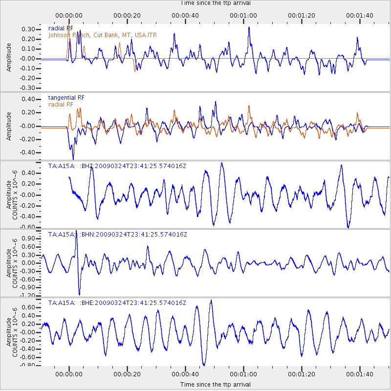
A15A Johnson Ranch, Cut Bank, MT, USA - Earthquake Result Viewer
*The percent match for this event was below the threshold and hence no stack was calculated.
| Earthquake location: |
New Britain Region, P.N.G. |
| Earthquake latitude/longitude: |
-5.1/151.8 |
| Earthquake time(UTC): |
2009/03/24 (083) 23:28:27 GMT |
| Earthquake Depth: |
36 km |
| Earthquake Magnitude: |
5.6 MB, 5.4 MS, 5.8 MW, 5.8 MW |
| Earthquake Catalog/Contributor: |
WHDF/NEIC |
|
| Network: |
TA USArray Transportable Network (new EarthScope stations) |
| Station: |
A15A Johnson Ranch, Cut Bank, MT, USA |
| Lat/Lon: |
48.98 N/112.73 W |
| Elevation: |
1236 m |
|
| Distance: |
97.4 deg |
| Az: |
41.409 deg |
| Baz: |
270.705 deg |
| Ray Param: |
$rayparam |
*The percent match for this event was below the threshold and hence was not used in the summary stack. |
|
| Radial Match: |
63.023163 % |
| Radial Bump: |
392 |
| Transverse Match: |
67.70691 % |
| Transverse Bump: |
400 |
| SOD ConfigId: |
2658 |
| Insert Time: |
2010-03-06 18:35:25.806 +0000 |
| GWidth: |
2.5 |
| Max Bumps: |
400 |
| Tol: |
0.001 |
|
Signal To Noise
| Channel | StoN | STA | LTA |
| TA:A15A: :BHN:20090324T23:41:25.574016Z | 3.8829842 | 5.408464E-7 | 1.3928627E-7 |
| TA:A15A: :BHE:20090324T23:41:25.574016Z | 0.81154865 | 1.858203E-7 | 2.2897E-7 |
| TA:A15A: :BHZ:20090324T23:41:25.574016Z | 0.8370503 | 1.6021636E-7 | 1.9140589E-7 |
| Arrivals |
| Ps | |
| PpPs | |
| PsPs/PpSs | |


