You are here: Home > Network List > TA - USArray Transportable Network (new EarthScope stations) Stations List
> Station A15A Johnson Ranch, Cut Bank, MT, USA > Earthquake Result Viewer
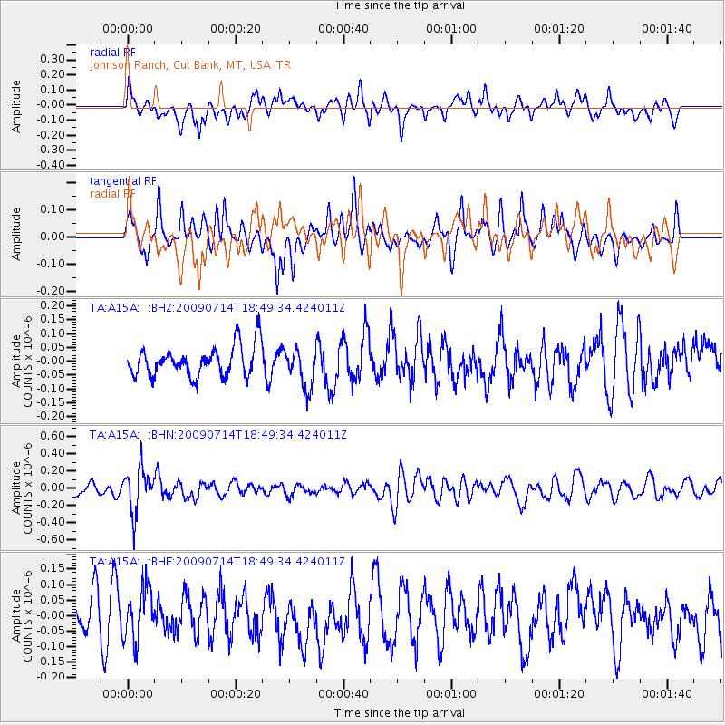
A15A Johnson Ranch, Cut Bank, MT, USA - Earthquake Result Viewer
*The percent match for this event was below the threshold and hence no stack was calculated.
| Earthquake location: |
Chile-Bolivia Border Region |
| Earthquake latitude/longitude: |
-21.8/-67.1 |
| Earthquake time(UTC): |
2009/07/14 (195) 18:38:08 GMT |
| Earthquake Depth: |
176 km |
| Earthquake Magnitude: |
5.7 MW, 5.4 MB, 5.7 MW |
| Earthquake Catalog/Contributor: |
WHDF/NEIC |
|
| Network: |
TA USArray Transportable Network (new EarthScope stations) |
| Station: |
A15A Johnson Ranch, Cut Bank, MT, USA |
| Lat/Lon: |
48.98 N/112.73 W |
| Elevation: |
1236 m |
|
| Distance: |
81.4 deg |
| Az: |
331.543 deg |
| Baz: |
137.778 deg |
| Ray Param: |
$rayparam |
*The percent match for this event was below the threshold and hence was not used in the summary stack. |
|
| Radial Match: |
53.749626 % |
| Radial Bump: |
400 |
| Transverse Match: |
52.588753 % |
| Transverse Bump: |
341 |
| SOD ConfigId: |
2648 |
| Insert Time: |
2010-03-06 18:35:33.968 +0000 |
| GWidth: |
2.5 |
| Max Bumps: |
400 |
| Tol: |
0.001 |
|
Signal To Noise
| Channel | StoN | STA | LTA |
| TA:A15A: :BHN:20090714T18:49:34.424011Z | 5.5072 | 2.5132326E-7 | 4.5635396E-8 |
| TA:A15A: :BHE:20090714T18:49:34.424011Z | 1.5953027 | 8.4185345E-8 | 5.2770766E-8 |
| TA:A15A: :BHZ:20090714T18:49:34.424011Z | 1.3017759 | 7.082696E-8 | 5.440795E-8 |
| Arrivals |
| Ps | |
| PpPs | |
| PsPs/PpSs | |


