You are here: Home > Network List > AZ - ANZA Regional Network Stations List
> Station SMER AZ.SMER > Earthquake Result Viewer
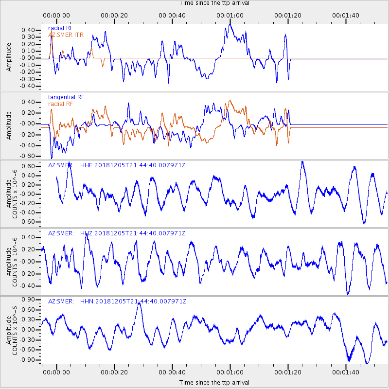
SMER AZ.SMER - Earthquake Result Viewer
*The percent match for this event was below the threshold and hence no stack was calculated.
| Earthquake location: |
Southeast Of Loyalty Islands |
| Earthquake latitude/longitude: |
-21.8/169.7 |
| Earthquake time(UTC): |
2018/12/05 (339) 21:32:19 GMT |
| Earthquake Depth: |
10 km |
| Earthquake Magnitude: |
5.5 Mww |
| Earthquake Catalog/Contributor: |
NEIC PDE/us |
|
| Network: |
AZ ANZA Regional Network |
| Station: |
SMER AZ.SMER |
| Lat/Lon: |
33.46 N/117.17 W |
| Elevation: |
355 m |
|
| Distance: |
88.6 deg |
| Az: |
53.14 deg |
| Baz: |
242.827 deg |
| Ray Param: |
$rayparam |
*The percent match for this event was below the threshold and hence was not used in the summary stack. |
|
| Radial Match: |
49.276077 % |
| Radial Bump: |
400 |
| Transverse Match: |
27.345747 % |
| Transverse Bump: |
400 |
| SOD ConfigId: |
13570011 |
| Insert Time: |
2019-05-02 01:01:10.856 +0000 |
| GWidth: |
2.5 |
| Max Bumps: |
400 |
| Tol: |
0.001 |
|
Signal To Noise
| Channel | StoN | STA | LTA |
| AZ:SMER: :HHZ:20181205T21:44:40.007971Z | 0.7257929 | 1.2465738E-7 | 1.7175336E-7 |
| AZ:SMER: :HHN:20181205T21:44:40.007971Z | 1.3008919 | 3.2046563E-7 | 2.46343E-7 |
| AZ:SMER: :HHE:20181205T21:44:40.007971Z | 1.3610867 | 2.7569104E-7 | 2.0255214E-7 |
| Arrivals |
| Ps | |
| PpPs | |
| PsPs/PpSs | |


