You are here: Home > Network List > TA - USArray Transportable Network (new EarthScope stations) Stations List
> Station B18K Kokolik River, AK, USA > Earthquake Result Viewer
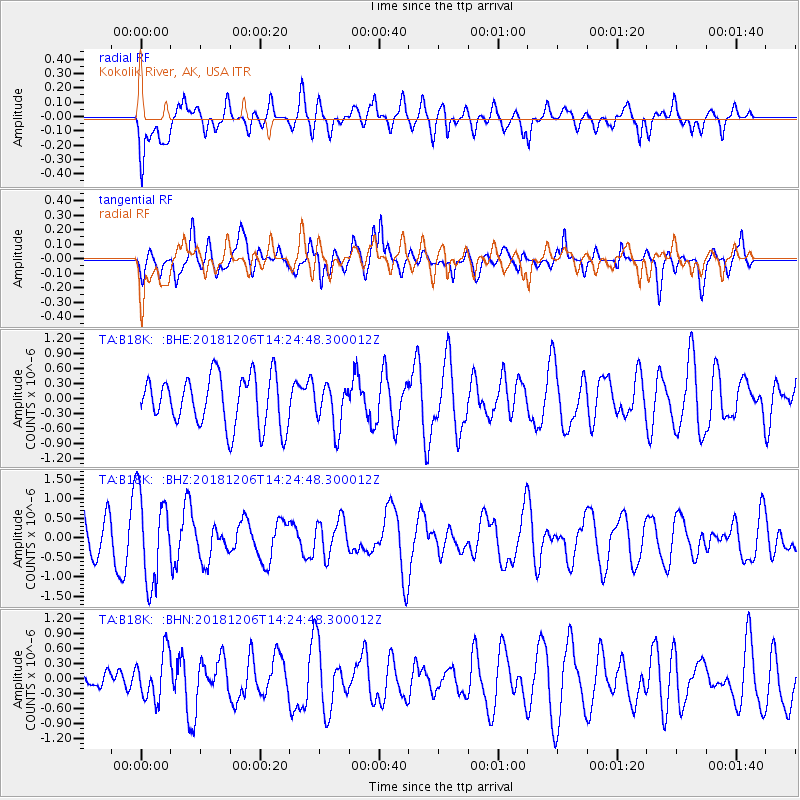
B18K Kokolik River, AK, USA - Earthquake Result Viewer
*The percent match for this event was below the threshold and hence no stack was calculated.
| Earthquake location: |
Mindanao, Philippines |
| Earthquake latitude/longitude: |
6.7/125.7 |
| Earthquake time(UTC): |
2018/12/06 (340) 14:13:43 GMT |
| Earthquake Depth: |
185 km |
| Earthquake Magnitude: |
5.3 Mww |
| Earthquake Catalog/Contributor: |
NEIC PDE/us |
|
| Network: |
TA USArray Transportable Network (new EarthScope stations) |
| Station: |
B18K Kokolik River, AK, USA |
| Lat/Lon: |
69.36 N/161.80 W |
| Elevation: |
222 m |
|
| Distance: |
77.7 deg |
| Az: |
20.252 deg |
| Baz: |
255.909 deg |
| Ray Param: |
$rayparam |
*The percent match for this event was below the threshold and hence was not used in the summary stack. |
|
| Radial Match: |
61.771023 % |
| Radial Bump: |
400 |
| Transverse Match: |
58.683804 % |
| Transverse Bump: |
400 |
| SOD ConfigId: |
13570011 |
| Insert Time: |
2019-05-02 01:11:03.461 +0000 |
| GWidth: |
2.5 |
| Max Bumps: |
400 |
| Tol: |
0.001 |
|
Signal To Noise
| Channel | StoN | STA | LTA |
| TA:B18K: :BHZ:20181206T14:24:48.300012Z | 2.4527264 | 1.1303099E-6 | 4.6083818E-7 |
| TA:B18K: :BHN:20181206T14:24:48.300012Z | 1.3955486 | 4.7574474E-7 | 3.409016E-7 |
| TA:B18K: :BHE:20181206T14:24:48.300012Z | 0.8582922 | 4.307715E-7 | 5.018938E-7 |
| Arrivals |
| Ps | |
| PpPs | |
| PsPs/PpSs | |


