You are here: Home > Network List > TA - USArray Transportable Network (new EarthScope stations) Stations List
> Station W27A Bowe Ranch, Endee, NM, USA > Earthquake Result Viewer
W27A Bowe Ranch, Endee, NM, USA - Earthquake Result Viewer
| Earthquake location: |
Tonga Islands |
| Earthquake latitude/longitude: |
-15.1/-173.5 |
| Earthquake time(UTC): |
2008/08/19 (232) 16:30:13 GMT |
| Earthquake Depth: |
8.0 km |
| Earthquake Magnitude: |
5.6 MB, 5.9 MS, 6.1 MW, 6.0 MW |
| Earthquake Catalog/Contributor: |
WHDF/NEIC |
|
| Network: |
TA USArray Transportable Network (new EarthScope stations) |
| Station: |
W27A Bowe Ranch, Endee, NM, USA |
| Lat/Lon: |
35.06 N/103.06 W |
| Elevation: |
1233 m |
|
| Distance: |
83.2 deg |
| Az: |
51.102 deg |
| Baz: |
246.412 deg |
| Ray Param: |
0.0463332 |
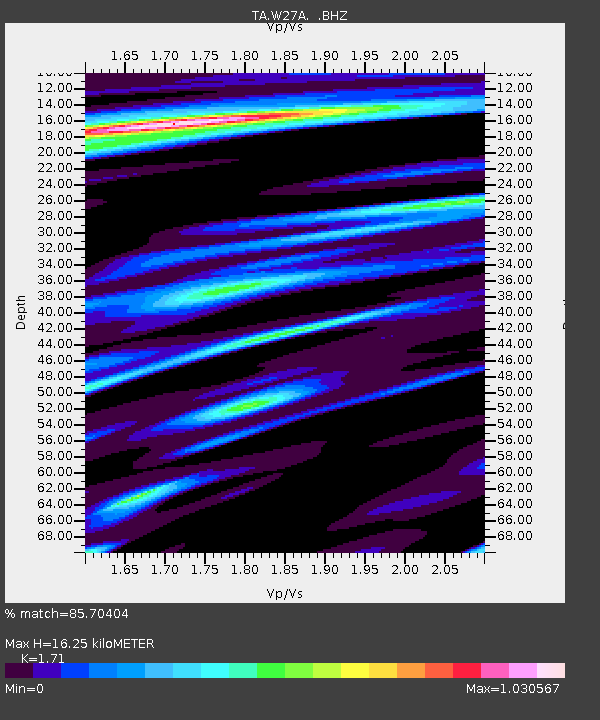
| Estimated Moho Depth: |
16.25 km |
| Estimated Crust Vp/Vs: |
1.71 |
| Assumed Crust Vp: |
6.242 km/s |
| Estimated Crust Vs: |
3.65 km/s |
| Estimated Crust Poisson's Ratio: |
0.24 |
|
| Radial Match: |
85.70404 % |
| Radial Bump: |
400 |
| Transverse Match: |
64.999435 % |
| Transverse Bump: |
400 |
| SOD ConfigId: |
2504 |
| Insert Time: |
2010-03-06 18:36:25.318 +0000 |
| GWidth: |
2.5 |
| Max Bumps: |
400 |
| Tol: |
0.001 |
|
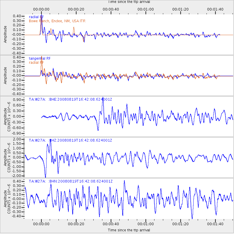
Signal To Noise
| Channel | StoN | STA | LTA |
| TA:W27A: :BHZ:20080819T16:42:08.624001Z | 9.389657 | 9.862794E-7 | 1.0503891E-7 |
| TA:W27A: :BHN:20080819T16:42:08.624001Z | 0.8262269 | 8.7828596E-8 | 1.0630082E-7 |
| TA:W27A: :BHE:20080819T16:42:08.624001Z | 3.546134 | 2.9556944E-7 | 8.334977E-8 |
| Arrivals |
| Ps | 1.9 SECOND |
| PpPs | 6.9 SECOND |
| PsPs/PpSs | 8.8 SECOND |


