You are here: Home > Network List > TA - USArray Transportable Network (new EarthScope stations) Stations List
> Station W27A Bowe Ranch, Endee, NM, USA > Earthquake Result Viewer
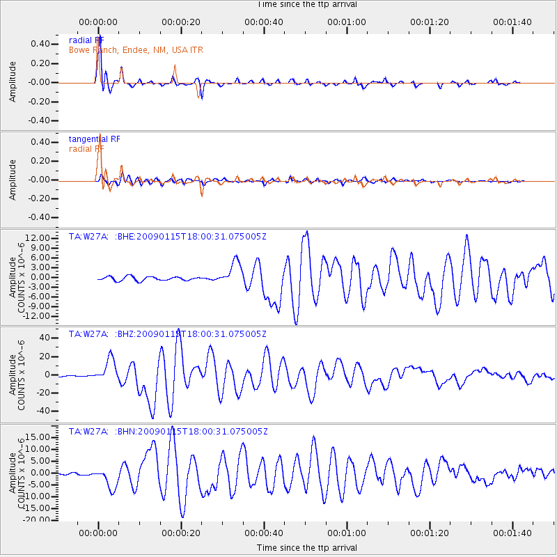
W27A Bowe Ranch, Endee, NM, USA - Earthquake Result Viewer
| Earthquake location: |
East Of Kuril Islands |
| Earthquake latitude/longitude: |
46.9/155.2 |
| Earthquake time(UTC): |
2009/01/15 (015) 17:49:39 GMT |
| Earthquake Depth: |
36 km |
| Earthquake Magnitude: |
6.9 MB, 7.5 MS, 7.4 MW, 7.4 MW |
| Earthquake Catalog/Contributor: |
WHDF/NEIC |
|
| Network: |
TA USArray Transportable Network (new EarthScope stations) |
| Station: |
W27A Bowe Ranch, Endee, NM, USA |
| Lat/Lon: |
35.06 N/103.06 W |
| Elevation: |
1233 m |
|
| Distance: |
72.5 deg |
| Az: |
57.362 deg |
| Baz: |
315.213 deg |
| Ray Param: |
0.053576075 |
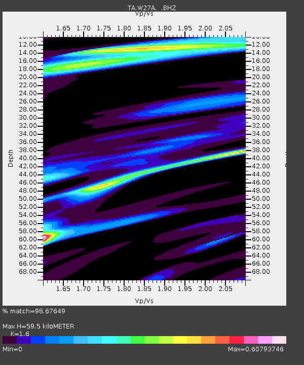
| Estimated Moho Depth: |
59.5 km |
| Estimated Crust Vp/Vs: |
1.60 |
| Assumed Crust Vp: |
6.242 km/s |
| Estimated Crust Vs: |
3.901 km/s |
| Estimated Crust Poisson's Ratio: |
0.18 |
|
| Radial Match: |
98.67649 % |
| Radial Bump: |
285 |
| Transverse Match: |
89.41092 % |
| Transverse Bump: |
400 |
| SOD ConfigId: |
2834 |
| Insert Time: |
2010-03-06 18:36:39.201 +0000 |
| GWidth: |
2.5 |
| Max Bumps: |
400 |
| Tol: |
0.001 |
|
Signal To Noise
| Channel | StoN | STA | LTA |
| TA:W27A: :BHZ:20090115T18:00:31.075005Z | 21.10183 | 1.3077501E-5 | 6.1973304E-7 |
| TA:W27A: :BHN:20090115T18:00:31.075005Z | 10.089624 | 4.546062E-6 | 4.50568E-7 |
| TA:W27A: :BHE:20090115T18:00:31.075005Z | 6.0506907 | 3.7205334E-6 | 6.14894E-7 |
| Arrivals |
| Ps | 5.9 SECOND |
| PpPs | 24 SECOND |
| PsPs/PpSs | 30 SECOND |


