You are here: Home > Network List > TA - USArray Transportable Network (new EarthScope stations) Stations List
> Station W27A Bowe Ranch, Endee, NM, USA > Earthquake Result Viewer
W27A Bowe Ranch, Endee, NM, USA - Earthquake Result Viewer
| Earthquake location: |
Off Coast Of Costa Rica |
| Earthquake latitude/longitude: |
7.9/-85.6 |
| Earthquake time(UTC): |
2009/08/13 (225) 09:37:35 GMT |
| Earthquake Depth: |
10 km |
| Earthquake Magnitude: |
5.8 MW, 5.3 MB |
| Earthquake Catalog/Contributor: |
WHDF/NEIC |
|
| Network: |
TA USArray Transportable Network (new EarthScope stations) |
| Station: |
W27A Bowe Ranch, Endee, NM, USA |
| Lat/Lon: |
35.06 N/103.06 W |
| Elevation: |
1233 m |
|
| Distance: |
31.4 deg |
| Az: |
331.837 deg |
| Baz: |
145.256 deg |
| Ray Param: |
0.079086475 |
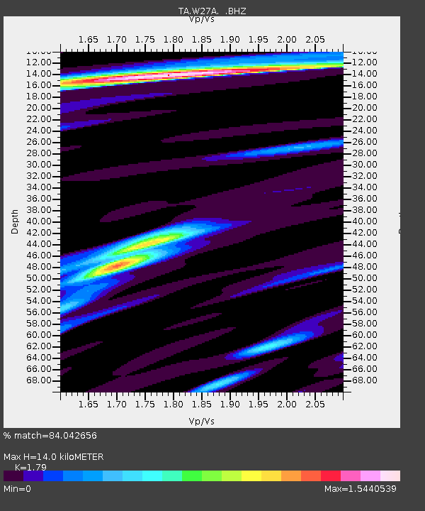
| Estimated Moho Depth: |
14.0 km |
| Estimated Crust Vp/Vs: |
1.79 |
| Assumed Crust Vp: |
6.242 km/s |
| Estimated Crust Vs: |
3.487 km/s |
| Estimated Crust Poisson's Ratio: |
0.27 |
|
| Radial Match: |
84.042656 % |
| Radial Bump: |
400 |
| Transverse Match: |
73.08889 % |
| Transverse Bump: |
400 |
| SOD ConfigId: |
2622 |
| Insert Time: |
2010-03-06 18:36:47.499 +0000 |
| GWidth: |
2.5 |
| Max Bumps: |
400 |
| Tol: |
0.001 |
|
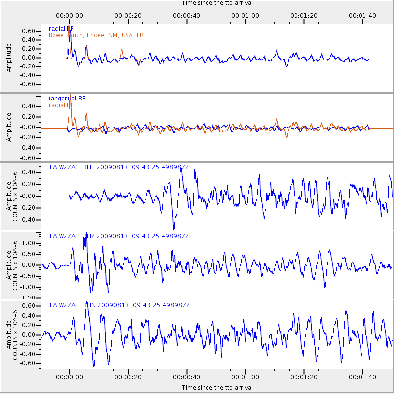
Signal To Noise
| Channel | StoN | STA | LTA |
| TA:W27A: :BHZ:20090813T09:43:25.498987Z | 5.7836456 | 4.4466626E-7 | 7.688339E-8 |
| TA:W27A: :BHN:20090813T09:43:25.498987Z | 3.1448047 | 1.9199587E-7 | 6.105176E-8 |
| TA:W27A: :BHE:20090813T09:43:25.498987Z | 3.3812833 | 1.4582895E-7 | 4.312829E-8 |
| Arrivals |
| Ps | 1.9 SECOND |
| PpPs | 5.8 SECOND |
| PsPs/PpSs | 7.7 SECOND |


