You are here: Home > Network List > TA - USArray Transportable Network (new EarthScope stations) Stations List
> Station K15K Wolf Creek Mountain, AK, USA > Earthquake Result Viewer
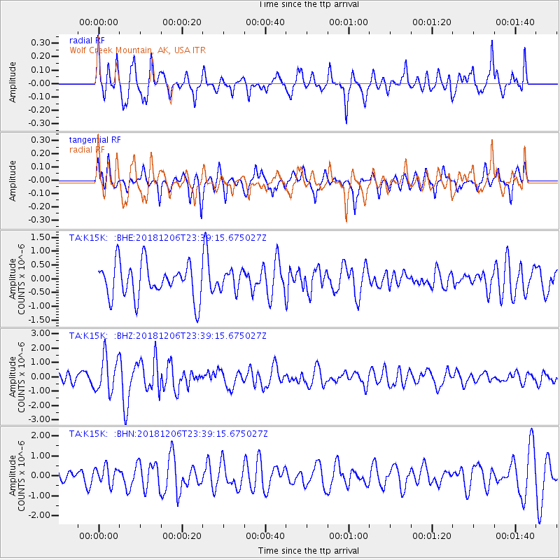
K15K Wolf Creek Mountain, AK, USA - Earthquake Result Viewer
*The percent match for this event was below the threshold and hence no stack was calculated.
| Earthquake location: |
Southeast Of Loyalty Islands |
| Earthquake latitude/longitude: |
-22.4/169.6 |
| Earthquake time(UTC): |
2018/12/06 (340) 23:26:59 GMT |
| Earthquake Depth: |
10 km |
| Earthquake Magnitude: |
5.7 Mww |
| Earthquake Catalog/Contributor: |
NEIC PDE/us |
|
| Network: |
TA USArray Transportable Network (new EarthScope stations) |
| Station: |
K15K Wolf Creek Mountain, AK, USA |
| Lat/Lon: |
62.29 N/161.53 W |
| Elevation: |
346 m |
|
| Distance: |
87.4 deg |
| Az: |
13.048 deg |
| Baz: |
206.561 deg |
| Ray Param: |
$rayparam |
*The percent match for this event was below the threshold and hence was not used in the summary stack. |
|
| Radial Match: |
73.65646 % |
| Radial Bump: |
400 |
| Transverse Match: |
55.380028 % |
| Transverse Bump: |
400 |
| SOD ConfigId: |
13570011 |
| Insert Time: |
2019-05-02 01:16:40.148 +0000 |
| GWidth: |
2.5 |
| Max Bumps: |
400 |
| Tol: |
0.001 |
|
Signal To Noise
| Channel | StoN | STA | LTA |
| TA:K15K: :BHZ:20181206T23:39:15.675027Z | 2.9185987 | 1.2761376E-6 | 4.3724327E-7 |
| TA:K15K: :BHN:20181206T23:39:15.675027Z | 1.3000437 | 4.3860496E-7 | 3.373771E-7 |
| TA:K15K: :BHE:20181206T23:39:15.675027Z | 0.5661994 | 3.5472996E-7 | 6.2651065E-7 |
| Arrivals |
| Ps | |
| PpPs | |
| PsPs/PpSs | |


