You are here: Home > Network List > TA - USArray Transportable Network (new EarthScope stations) Stations List
> Station M16K Timber Creek, AK, USA > Earthquake Result Viewer
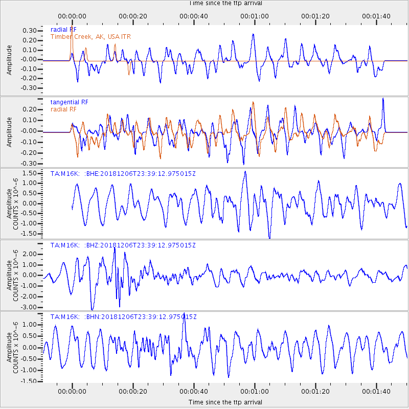
M16K Timber Creek, AK, USA - Earthquake Result Viewer
*The percent match for this event was below the threshold and hence no stack was calculated.
| Earthquake location: |
Southeast Of Loyalty Islands |
| Earthquake latitude/longitude: |
-22.4/169.6 |
| Earthquake time(UTC): |
2018/12/06 (340) 23:26:59 GMT |
| Earthquake Depth: |
10 km |
| Earthquake Magnitude: |
5.7 Mww |
| Earthquake Catalog/Contributor: |
NEIC PDE/us |
|
| Network: |
TA USArray Transportable Network (new EarthScope stations) |
| Station: |
M16K Timber Creek, AK, USA |
| Lat/Lon: |
61.02 N/158.96 W |
| Elevation: |
394 m |
|
| Distance: |
86.9 deg |
| Az: |
14.73 deg |
| Baz: |
208.905 deg |
| Ray Param: |
$rayparam |
*The percent match for this event was below the threshold and hence was not used in the summary stack. |
|
| Radial Match: |
60.17266 % |
| Radial Bump: |
400 |
| Transverse Match: |
64.72209 % |
| Transverse Bump: |
400 |
| SOD ConfigId: |
13570011 |
| Insert Time: |
2019-05-02 01:16:43.877 +0000 |
| GWidth: |
2.5 |
| Max Bumps: |
400 |
| Tol: |
0.001 |
|
Signal To Noise
| Channel | StoN | STA | LTA |
| TA:M16K: :BHZ:20181206T23:39:12.975015Z | 2.2890015 | 1.1052568E-6 | 4.8285546E-7 |
| TA:M16K: :BHN:20181206T23:39:12.975015Z | 1.3708714 | 5.952699E-7 | 4.342274E-7 |
| TA:M16K: :BHE:20181206T23:39:12.975015Z | 0.909765 | 5.3647636E-7 | 5.8968675E-7 |
| Arrivals |
| Ps | |
| PpPs | |
| PsPs/PpSs | |


