You are here: Home > Network List > TA - USArray Transportable Network (new EarthScope stations) Stations List
> Station W27A Bowe Ranch, Endee, NM, USA > Earthquake Result Viewer
W27A Bowe Ranch, Endee, NM, USA - Earthquake Result Viewer
| Earthquake location: |
Northern Mid-Atlantic Ridge |
| Earthquake latitude/longitude: |
23.9/-46.1 |
| Earthquake time(UTC): |
2009/06/06 (157) 20:33:28 GMT |
| Earthquake Depth: |
14 km |
| Earthquake Magnitude: |
6.0 MB, 5.7 MS, 6.0 MW, 6.0 MW |
| Earthquake Catalog/Contributor: |
WHDF/NEIC |
|
| Network: |
TA USArray Transportable Network (new EarthScope stations) |
| Station: |
W27A Bowe Ranch, Endee, NM, USA |
| Lat/Lon: |
35.06 N/103.06 W |
| Elevation: |
1233 m |
|
| Distance: |
50.2 deg |
| Az: |
296.553 deg |
| Baz: |
86.679 deg |
| Ray Param: |
0.068179436 |
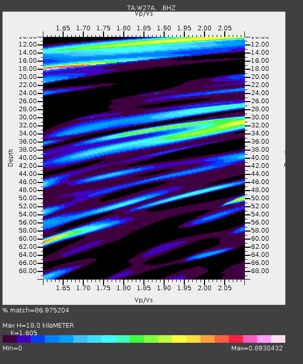
| Estimated Moho Depth: |
18.0 km |
| Estimated Crust Vp/Vs: |
1.61 |
| Assumed Crust Vp: |
6.242 km/s |
| Estimated Crust Vs: |
3.889 km/s |
| Estimated Crust Poisson's Ratio: |
0.18 |
|
| Radial Match: |
86.975204 % |
| Radial Bump: |
400 |
| Transverse Match: |
56.13868 % |
| Transverse Bump: |
400 |
| SOD ConfigId: |
2648 |
| Insert Time: |
2010-03-06 18:37:06.044 +0000 |
| GWidth: |
2.5 |
| Max Bumps: |
400 |
| Tol: |
0.001 |
|
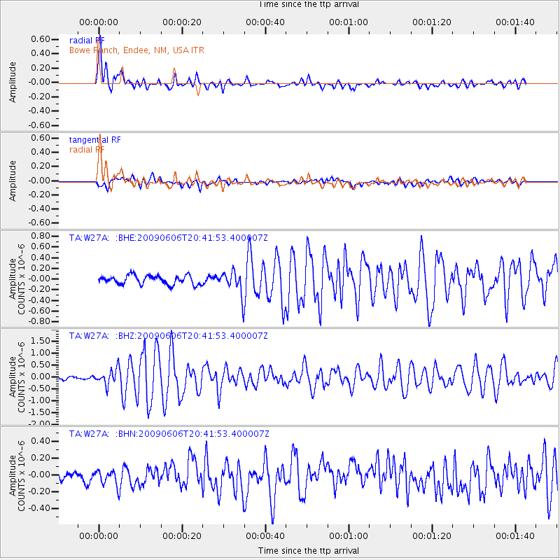
Signal To Noise
| Channel | StoN | STA | LTA |
| TA:W27A: :BHZ:20090606T20:41:53.400007Z | 4.322375 | 3.307977E-7 | 7.653147E-8 |
| TA:W27A: :BHN:20090606T20:41:53.400007Z | 0.7309209 | 9.228206E-8 | 1.262545E-7 |
| TA:W27A: :BHE:20090606T20:41:53.400007Z | 2.8818421 | 2.3513088E-7 | 8.159048E-8 |
| Arrivals |
| Ps | 1.9 SECOND |
| PpPs | 7.1 SECOND |
| PsPs/PpSs | 8.9 SECOND |


