You are here: Home > Network List > AZ - ANZA Regional Network Stations List
> Station SMER AZ.SMER > Earthquake Result Viewer
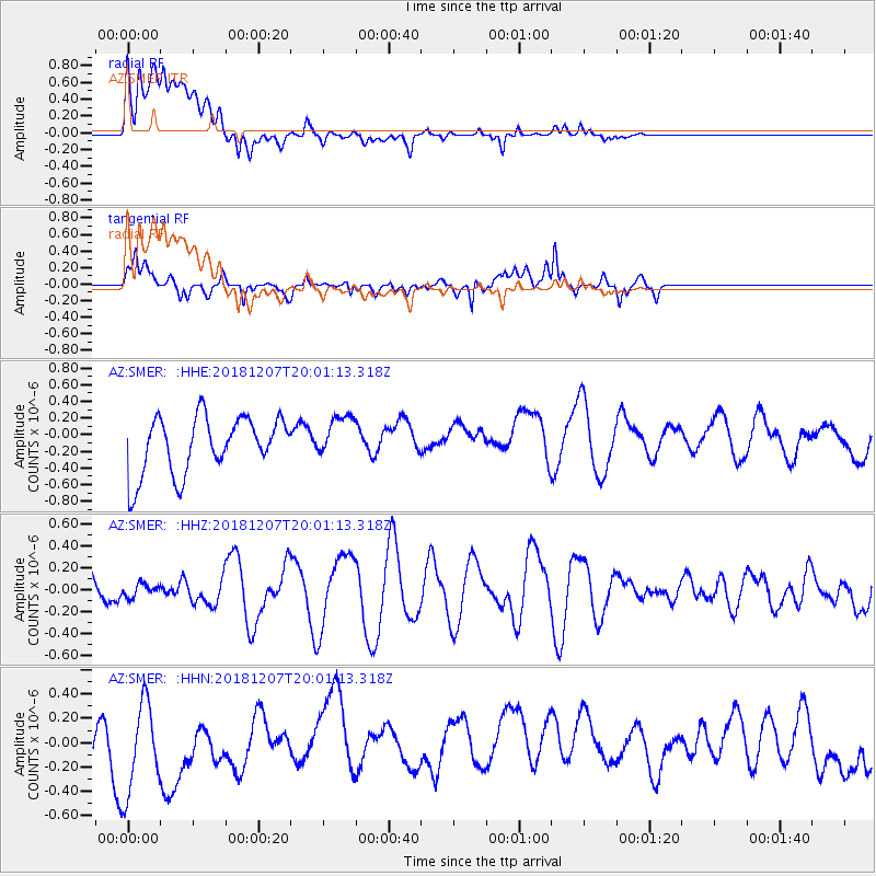
SMER AZ.SMER - Earthquake Result Viewer
*The percent match for this event was below the threshold and hence no stack was calculated.
| Earthquake location: |
Southern Alaska |
| Earthquake latitude/longitude: |
61.3/-150.0 |
| Earthquake time(UTC): |
2018/12/07 (341) 19:54:54 GMT |
| Earthquake Depth: |
29 km |
| Earthquake Magnitude: |
3.5 ML |
| Earthquake Catalog/Contributor: |
NEIC PDE/ak |
|
| Network: |
AZ ANZA Regional Network |
| Station: |
SMER AZ.SMER |
| Lat/Lon: |
33.46 N/117.17 W |
| Elevation: |
355 m |
|
| Distance: |
35.0 deg |
| Az: |
127.716 deg |
| Baz: |
332.843 deg |
| Ray Param: |
$rayparam |
*The percent match for this event was below the threshold and hence was not used in the summary stack. |
|
| Radial Match: |
45.35705 % |
| Radial Bump: |
400 |
| Transverse Match: |
73.31832 % |
| Transverse Bump: |
400 |
| SOD ConfigId: |
13570011 |
| Insert Time: |
2019-05-02 01:18:45.803 +0000 |
| GWidth: |
2.5 |
| Max Bumps: |
400 |
| Tol: |
0.001 |
|
Signal To Noise
| Channel | StoN | STA | LTA |
| AZ:SMER: :HHZ:20181207T20:01:13.318Z | 0.1753489 | 5.692991E-8 | 3.246665E-7 |
| AZ:SMER: :HHN:20181207T20:01:13.318Z | 0.9817124 | 4.2765276E-7 | 4.3561917E-7 |
| AZ:SMER: :HHE:20181207T20:01:13.318Z | 0.7755273 | 2.6536324E-7 | 3.421714E-7 |
| Arrivals |
| Ps | |
| PpPs | |
| PsPs/PpSs | |


