You are here: Home > Network List > TS - TERRAscope (Southern California Seismic Network) Stations List
> Station BAR Barrett Dam, California, USA > Earthquake Result Viewer
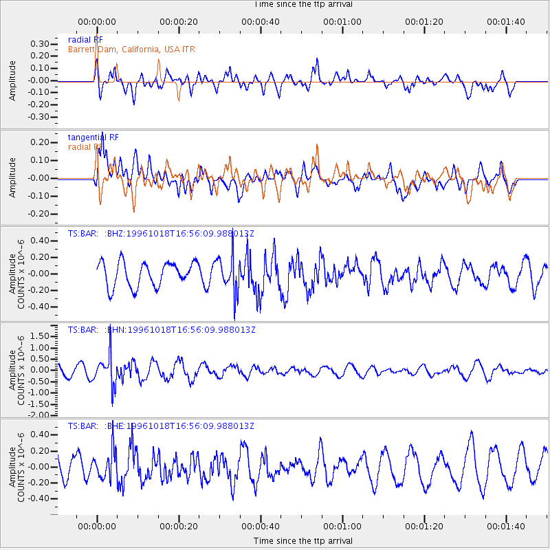
BAR Barrett Dam, California, USA - Earthquake Result Viewer
*The percent match for this event was below the threshold and hence no stack was calculated.
| Earthquake location: |
Near S. Coast Of Honshu, Japan |
| Earthquake latitude/longitude: |
33.7/137.4 |
| Earthquake time(UTC): |
1996/10/18 (292) 16:44:47 GMT |
| Earthquake Depth: |
338 km |
| Earthquake Magnitude: |
5.6 UNKNOWN, 5.4 MB, 5.6 MW |
| Earthquake Catalog/Contributor: |
WHDF/NEIC |
|
| Network: |
TS TERRAscope (Southern California Seismic Network) |
| Station: |
BAR Barrett Dam, California, USA |
| Lat/Lon: |
32.68 N/116.67 W |
| Elevation: |
548 m |
|
| Distance: |
84.0 deg |
| Az: |
54.624 deg |
| Baz: |
306.278 deg |
| Ray Param: |
$rayparam |
*The percent match for this event was below the threshold and hence was not used in the summary stack. |
|
| Radial Match: |
59.964478 % |
| Radial Bump: |
400 |
| Transverse Match: |
61.403873 % |
| Transverse Bump: |
400 |
| SOD ConfigId: |
4480 |
| Insert Time: |
2010-02-26 14:01:46.596 +0000 |
| GWidth: |
2.5 |
| Max Bumps: |
400 |
| Tol: |
0.001 |
|
Signal To Noise
| Channel | StoN | STA | LTA |
| TS:BAR: :BHN:19961018T16:56:09.988013Z | 3.2382517 | 6.6893506E-7 | 2.0657292E-7 |
| TS:BAR: :BHE:19961018T16:56:09.988013Z | 1.3902135 | 1.8635392E-7 | 1.3404697E-7 |
| TS:BAR: :BHZ:19961018T16:56:09.988013Z | 1.4685262 | 2.1608614E-7 | 1.4714489E-7 |
| Arrivals |
| Ps | |
| PpPs | |
| PsPs/PpSs | |


