You are here: Home > Network List > AU - Australian Seismological Centre Stations List
> Station MEEK Meekatharra, Western Australia > Earthquake Result Viewer
MEEK Meekatharra, Western Australia - Earthquake Result Viewer
| Earthquake location: |
South Sandwich Islands Region |
| Earthquake latitude/longitude: |
-58.6/-26.5 |
| Earthquake time(UTC): |
2018/12/11 (345) 02:26:32 GMT |
| Earthquake Depth: |
165 km |
| Earthquake Magnitude: |
7.1 mww |
| Earthquake Catalog/Contributor: |
NEIC PDE/us |
|
| Network: |
AU Australian Seismological Centre |
| Station: |
MEEK Meekatharra, Western Australia |
| Lat/Lon: |
26.64 S/118.61 E |
| Elevation: |
530 m |
|
| Distance: |
90.2 deg |
| Az: |
149.179 deg |
| Baz: |
197.441 deg |
| Ray Param: |
0.041651882 |
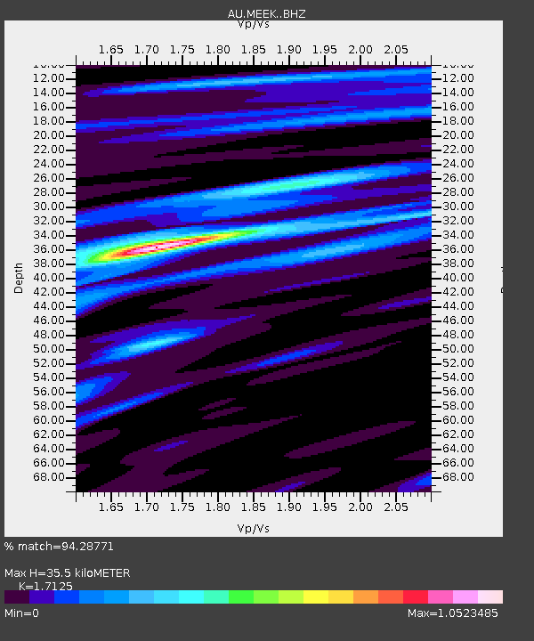
| Estimated Moho Depth: |
35.5 km |
| Estimated Crust Vp/Vs: |
1.71 |
| Assumed Crust Vp: |
6.459 km/s |
| Estimated Crust Vs: |
3.772 km/s |
| Estimated Crust Poisson's Ratio: |
0.24 |
|
| Radial Match: |
94.28771 % |
| Radial Bump: |
321 |
| Transverse Match: |
74.8714 % |
| Transverse Bump: |
400 |
| SOD ConfigId: |
13570011 |
| Insert Time: |
2019-05-02 01:25:58.905 +0000 |
| GWidth: |
2.5 |
| Max Bumps: |
400 |
| Tol: |
0.001 |
|

Signal To Noise
| Channel | StoN | STA | LTA |
| AU:MEEK: :BHZ:20181211T02:38:43.394001Z | 2.8188546 | 8.267841E-7 | 2.93305E-7 |
| AU:MEEK: :BHN:20181211T02:38:43.394001Z | 1.0794753 | 2.4071602E-7 | 2.2299353E-7 |
| AU:MEEK: :BHE:20181211T02:38:43.394001Z | 1.0574878 | 3.2544662E-7 | 3.0775448E-7 |
| Arrivals |
| Ps | 4.0 SECOND |
| PpPs | 15 SECOND |
| PsPs/PpSs | 19 SECOND |


