You are here: Home > Network List > BX - Botswana Seismological Network Stations List
> Station SKOMA Sekoma > Earthquake Result Viewer
SKOMA Sekoma - Earthquake Result Viewer
| Earthquake location: |
South Sandwich Islands Region |
| Earthquake latitude/longitude: |
-58.6/-26.5 |
| Earthquake time(UTC): |
2018/12/11 (345) 02:26:32 GMT |
| Earthquake Depth: |
165 km |
| Earthquake Magnitude: |
7.1 mww |
| Earthquake Catalog/Contributor: |
NEIC PDE/us |
|
| Network: |
BX Botswana Seismological Network |
| Station: |
SKOMA Sekoma |
| Lat/Lon: |
24.52 S/23.93 E |
| Elevation: |
980 m |
|
| Distance: |
49.0 deg |
| Az: |
68.346 deg |
| Baz: |
212.292 deg |
| Ray Param: |
0.06837775 |
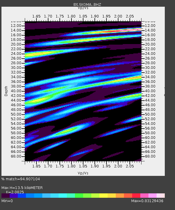
| Estimated Moho Depth: |
13.5 km |
| Estimated Crust Vp/Vs: |
2.08 |
| Assumed Crust Vp: |
6.612 km/s |
| Estimated Crust Vs: |
3.175 km/s |
| Estimated Crust Poisson's Ratio: |
0.35 |
|
| Radial Match: |
94.907104 % |
| Radial Bump: |
367 |
| Transverse Match: |
72.71807 % |
| Transverse Bump: |
400 |
| SOD ConfigId: |
13570011 |
| Insert Time: |
2019-05-02 01:26:32.945 +0000 |
| GWidth: |
2.5 |
| Max Bumps: |
400 |
| Tol: |
0.001 |
|

Signal To Noise
| Channel | StoN | STA | LTA |
| BX:SKOMA: :BHZ:20181211T02:34:32.378987Z | 136.66731 | 2.931384E-5 | 2.144905E-7 |
| BX:SKOMA: :BHN:20181211T02:34:32.378987Z | 23.01653 | 1.2881223E-5 | 5.5965097E-7 |
| BX:SKOMA: :BHE:20181211T02:34:32.378987Z | 13.671329 | 7.9471265E-6 | 5.8129876E-7 |
| Arrivals |
| Ps | 2.3 SECOND |
| PpPs | 6.0 SECOND |
| PsPs/PpSs | 8.3 SECOND |


