You are here: Home > Network List > C1 - Red Sismologica Nacional Stations List
> Station AP01 Chacalluta > Earthquake Result Viewer
AP01 Chacalluta - Earthquake Result Viewer
| Earthquake location: |
South Sandwich Islands Region |
| Earthquake latitude/longitude: |
-58.6/-26.5 |
| Earthquake time(UTC): |
2018/12/11 (345) 02:26:32 GMT |
| Earthquake Depth: |
165 km |
| Earthquake Magnitude: |
7.1 mww |
| Earthquake Catalog/Contributor: |
NEIC PDE/us |
|
| Network: |
C1 Red Sismologica Nacional |
| Station: |
AP01 Chacalluta |
| Lat/Lon: |
18.37 S/70.34 W |
| Elevation: |
21 m |
|
| Distance: |
51.3 deg |
| Az: |
302.492 deg |
| Baz: |
152.287 deg |
| Ray Param: |
0.066927105 |
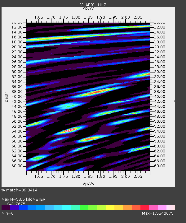
| Estimated Moho Depth: |
53.5 km |
| Estimated Crust Vp/Vs: |
1.77 |
| Assumed Crust Vp: |
4.24 km/s |
| Estimated Crust Vs: |
2.399 km/s |
| Estimated Crust Poisson's Ratio: |
0.26 |
|
| Radial Match: |
89.0414 % |
| Radial Bump: |
400 |
| Transverse Match: |
69.684296 % |
| Transverse Bump: |
400 |
| SOD ConfigId: |
13570011 |
| Insert Time: |
2019-05-02 01:26:48.297 +0000 |
| GWidth: |
2.5 |
| Max Bumps: |
400 |
| Tol: |
0.001 |
|

Signal To Noise
| Channel | StoN | STA | LTA |
| C1:AP01: :HHZ:20181211T02:34:49.309987Z | 6.035157 | 3.303848E-6 | 5.474336E-7 |
| C1:AP01: :HHN:20181211T02:34:49.309987Z | 2.59712 | 1.4525783E-6 | 5.593035E-7 |
| C1:AP01: :HHE:20181211T02:34:49.309987Z | 2.0878122 | 1.1121242E-6 | 5.3267445E-7 |
| Arrivals |
| Ps | 9.9 SECOND |
| PpPs | 34 SECOND |
| PsPs/PpSs | 44 SECOND |


