You are here: Home > Network List > C1 - Red Sismologica Nacional Stations List
> Station LR04 Corral > Earthquake Result Viewer
LR04 Corral - Earthquake Result Viewer
| Earthquake location: |
South Sandwich Islands Region |
| Earthquake latitude/longitude: |
-58.6/-26.5 |
| Earthquake time(UTC): |
2018/12/11 (345) 02:26:32 GMT |
| Earthquake Depth: |
165 km |
| Earthquake Magnitude: |
7.1 mww |
| Earthquake Catalog/Contributor: |
NEIC PDE/us |
|
| Network: |
C1 Red Sismologica Nacional |
| Station: |
LR04 Corral |
| Lat/Lon: |
39.88 S/73.43 W |
| Elevation: |
94 m |
|
| Distance: |
35.0 deg |
| Az: |
281.366 deg |
| Baz: |
138.158 deg |
| Ray Param: |
0.07686949 |
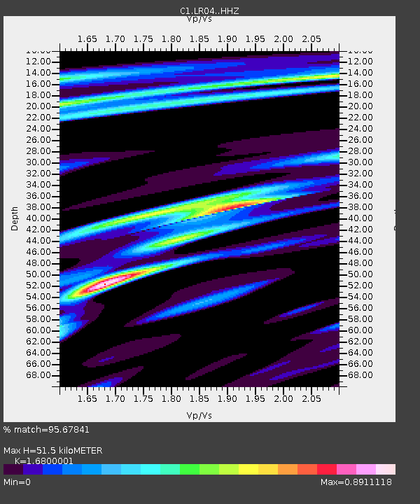
| Estimated Moho Depth: |
51.5 km |
| Estimated Crust Vp/Vs: |
1.68 |
| Assumed Crust Vp: |
6.597 km/s |
| Estimated Crust Vs: |
3.927 km/s |
| Estimated Crust Poisson's Ratio: |
0.23 |
|
| Radial Match: |
95.67841 % |
| Radial Bump: |
228 |
| Transverse Match: |
74.130844 % |
| Transverse Bump: |
400 |
| SOD ConfigId: |
13570011 |
| Insert Time: |
2019-05-02 01:27:04.027 +0000 |
| GWidth: |
2.5 |
| Max Bumps: |
400 |
| Tol: |
0.001 |
|

Signal To Noise
| Channel | StoN | STA | LTA |
| C1:LR04: :HHZ:20181211T02:32:39.03899Z | 26.597805 | 8.825109E-6 | 3.317984E-7 |
| C1:LR04: :HHN:20181211T02:32:39.03899Z | 26.033373 | 6.8920126E-6 | 2.647376E-7 |
| C1:LR04: :HHE:20181211T02:32:39.03899Z | 41.24265 | 9.026845E-6 | 2.1887162E-7 |
| Arrivals |
| Ps | 5.8 SECOND |
| PpPs | 19 SECOND |
| PsPs/PpSs | 25 SECOND |


