You are here: Home > Network List > US - United States National Seismic Network Stations List
> Station EGMT Eagleton, Montana, USA > Earthquake Result Viewer
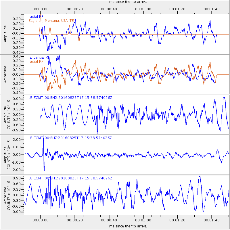
EGMT Eagleton, Montana, USA - Earthquake Result Viewer
*The percent match for this event was below the threshold and hence no stack was calculated.
| Earthquake location: |
Southeast Of Honshu, Japan |
| Earthquake latitude/longitude: |
30.6/137.8 |
| Earthquake time(UTC): |
2016/08/25 (238) 17:04:43 GMT |
| Earthquake Depth: |
456 km |
| Earthquake Magnitude: |
5.9 MWW, 5.9 MWB |
| Earthquake Catalog/Contributor: |
NEIC PDE/NEIC COMCAT |
|
| Network: |
US United States National Seismic Network |
| Station: |
EGMT Eagleton, Montana, USA |
| Lat/Lon: |
48.02 N/109.75 W |
| Elevation: |
1055 m |
|
| Distance: |
81.1 deg |
| Az: |
38.921 deg |
| Baz: |
306.214 deg |
| Ray Param: |
$rayparam |
*The percent match for this event was below the threshold and hence was not used in the summary stack. |
|
| Radial Match: |
48.26625 % |
| Radial Bump: |
400 |
| Transverse Match: |
64.11836 % |
| Transverse Bump: |
400 |
| SOD ConfigId: |
1634031 |
| Insert Time: |
2016-09-08 17:08:07.163 +0000 |
| GWidth: |
2.5 |
| Max Bumps: |
400 |
| Tol: |
0.001 |
|
Signal To Noise
| Channel | StoN | STA | LTA |
| US:EGMT:00:BHZ:20160825T17:15:38.574026Z | 3.7805293 | 8.3489886E-7 | 2.2084178E-7 |
| US:EGMT:00:BH1:20160825T17:15:38.574026Z | 1.4147617 | 3.491081E-7 | 2.4676106E-7 |
| US:EGMT:00:BH2:20160825T17:15:38.574026Z | 1.1387918 | 4.3791167E-7 | 3.8454056E-7 |
| Arrivals |
| Ps | |
| PpPs | |
| PsPs/PpSs | |


