You are here: Home > Network List > TC - Red Sismólogica Nacional de Costa Rica Stations List
> Station TRT2 Tortugero > Earthquake Result Viewer
TRT2 Tortugero - Earthquake Result Viewer
| Earthquake location: |
South Sandwich Islands Region |
| Earthquake latitude/longitude: |
-58.6/-26.5 |
| Earthquake time(UTC): |
2018/12/11 (345) 02:26:32 GMT |
| Earthquake Depth: |
165 km |
| Earthquake Magnitude: |
7.1 mww |
| Earthquake Catalog/Contributor: |
NEIC PDE/us |
|
| Network: |
TC Red Sismólogica Nacional de Costa Rica |
| Station: |
TRT2 Tortugero |
| Lat/Lon: |
10.56 N/83.74 W |
| Elevation: |
46 m |
|
| Distance: |
82.9 deg |
| Az: |
303.537 deg |
| Baz: |
153.651 deg |
| Ray Param: |
0.046164952 |
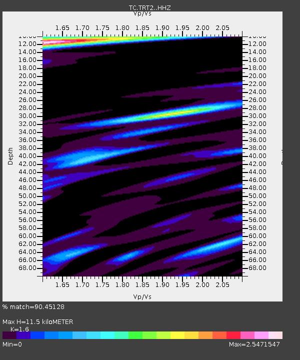
| Estimated Moho Depth: |
11.5 km |
| Estimated Crust Vp/Vs: |
1.60 |
| Assumed Crust Vp: |
5.989 km/s |
| Estimated Crust Vs: |
3.743 km/s |
| Estimated Crust Poisson's Ratio: |
0.18 |
|
| Radial Match: |
90.45128 % |
| Radial Bump: |
350 |
| Transverse Match: |
82.11162 % |
| Transverse Bump: |
327 |
| SOD ConfigId: |
13570011 |
| Insert Time: |
2019-05-02 01:28:35.362 +0000 |
| GWidth: |
2.5 |
| Max Bumps: |
400 |
| Tol: |
0.001 |
|

Signal To Noise
| Channel | StoN | STA | LTA |
| TC:TRT2: :HHZ:20181211T02:38:07.909993Z | 10.564967 | 2.025923E-6 | 1.9175857E-7 |
| TC:TRT2: :HHN:20181211T02:38:07.909993Z | 1.853224 | 6.417125E-7 | 3.4626817E-7 |
| TC:TRT2: :HHE:20181211T02:38:07.909993Z | 2.6950243 | 9.0005767E-7 | 3.3397015E-7 |
| Arrivals |
| Ps | 1.2 SECOND |
| PpPs | 4.9 SECOND |
| PsPs/PpSs | 6.1 SECOND |


