You are here: Home > Network List > WC - Curacao Seismic Network Stations List
> Station HATO Hato, Curacao > Earthquake Result Viewer
HATO Hato, Curacao - Earthquake Result Viewer
| Earthquake location: |
South Sandwich Islands Region |
| Earthquake latitude/longitude: |
-58.6/-26.5 |
| Earthquake time(UTC): |
2018/12/11 (345) 02:26:32 GMT |
| Earthquake Depth: |
165 km |
| Earthquake Magnitude: |
7.1 mww |
| Earthquake Catalog/Contributor: |
NEIC PDE/us |
|
| Network: |
WC Curacao Seismic Network |
| Station: |
HATO Hato, Curacao |
| Lat/Lon: |
12.18 N/68.96 W |
| Elevation: |
40 m |
|
| Distance: |
78.5 deg |
| Az: |
317.628 deg |
| Baz: |
158.845 deg |
| Ray Param: |
0.049177106 |
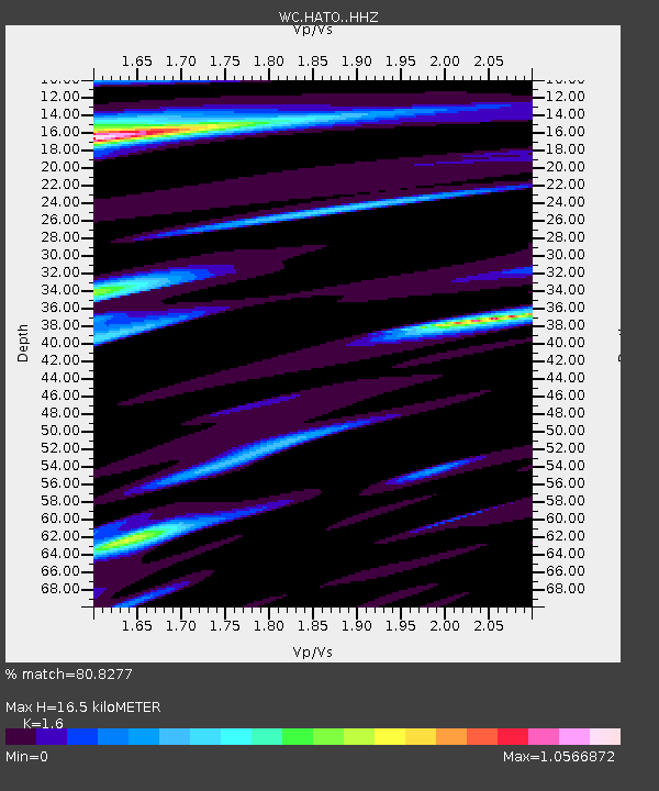
| Estimated Moho Depth: |
16.5 km |
| Estimated Crust Vp/Vs: |
1.60 |
| Assumed Crust Vp: |
5.88 km/s |
| Estimated Crust Vs: |
3.675 km/s |
| Estimated Crust Poisson's Ratio: |
0.18 |
|
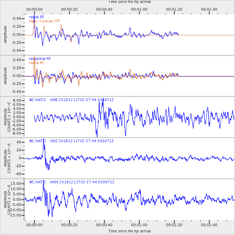
| Radial Match: |
80.8277 % |
| Radial Bump: |
400 |
| Transverse Match: |
73.071465 % |
| Transverse Bump: |
400 |
| SOD ConfigId: |
13570011 |
| Insert Time: |
2019-05-02 01:28:41.226 +0000 |
| GWidth: |
2.5 |
| Max Bumps: |
400 |
| Tol: |
0.001 |
|
Signal To Noise
| Channel | StoN | STA | LTA |
| WC:HATO: :HHZ:20181211T02:37:44.699971Z | 3.0276234 | 3.1379625E-6 | 1.0364441E-6 |
| WC:HATO: :HHN:20181211T02:37:44.699971Z | 1.9905705 | 2.0039024E-6 | 1.0066975E-6 |
| WC:HATO: :HHE:20181211T02:37:44.699971Z | 0.97972405 | 9.813137E-7 | 1.0016225E-6 |
| Arrivals |
| Ps | 1.7 SECOND |
| PpPs | 7.1 SECOND |
| PsPs/PpSs | 8.8 SECOND |


