You are here: Home > Network List > YT07 - POLENET Stations List
> Station THUR THUR > Earthquake Result Viewer
THUR THUR - Earthquake Result Viewer
| Earthquake location: |
South Sandwich Islands Region |
| Earthquake latitude/longitude: |
-58.6/-26.5 |
| Earthquake time(UTC): |
2018/12/11 (345) 02:26:32 GMT |
| Earthquake Depth: |
165 km |
| Earthquake Magnitude: |
7.1 mww |
| Earthquake Catalog/Contributor: |
NEIC PDE/us |
|
| Network: |
YT POLENET |
| Station: |
THUR THUR |
| Lat/Lon: |
72.53 S/97.56 W |
| Elevation: |
239 m |
|
| Distance: |
30.3 deg |
| Az: |
214.501 deg |
| Baz: |
100.925 deg |
| Ray Param: |
0.07907032 |
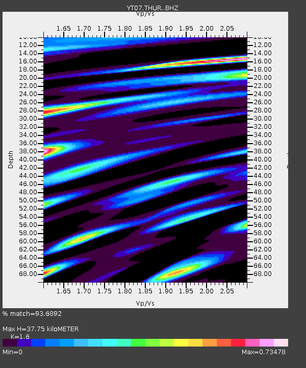
| Estimated Moho Depth: |
37.75 km |
| Estimated Crust Vp/Vs: |
1.60 |
| Assumed Crust Vp: |
6.43 km/s |
| Estimated Crust Vs: |
4.019 km/s |
| Estimated Crust Poisson's Ratio: |
0.18 |
|
| Radial Match: |
93.6892 % |
| Radial Bump: |
337 |
| Transverse Match: |
79.06404 % |
| Transverse Bump: |
400 |
| SOD ConfigId: |
13570011 |
| Insert Time: |
2019-05-02 01:28:46.786 +0000 |
| GWidth: |
2.5 |
| Max Bumps: |
400 |
| Tol: |
0.001 |
|

Signal To Noise
| Channel | StoN | STA | LTA |
| YT:THUR: :BHZ:20181211T02:31:58.249989Z | 8.108203 | 1.0232218E-6 | 1.2619587E-7 |
| YT:THUR: :BHN:20181211T02:31:58.249989Z | 1.4982812 | 1.4581781E-7 | 9.732339E-8 |
| YT:THUR: :BHE:20181211T02:31:58.249989Z | 6.0383377 | 6.4404605E-7 | 1.066595E-7 |
| Arrivals |
| Ps | 3.9 SECOND |
| PpPs | 14 SECOND |
| PsPs/PpSs | 18 SECOND |


