You are here: Home > Network List > TA - USArray Transportable Network (new EarthScope stations) Stations List
> Station W27A Bowe Ranch, Endee, NM, USA > Earthquake Result Viewer
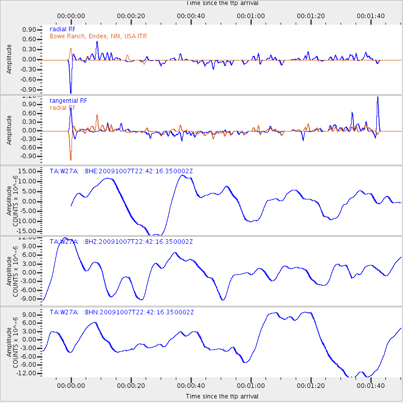
W27A Bowe Ranch, Endee, NM, USA - Earthquake Result Viewer
*The percent match for this event was below the threshold and hence no stack was calculated.
| Earthquake location: |
Santa Cruz Islands |
| Earthquake latitude/longitude: |
-11.5/166.0 |
| Earthquake time(UTC): |
2009/10/07 (280) 22:29:18 GMT |
| Earthquake Depth: |
35 km |
| Earthquake Magnitude: |
5.5 MB |
| Earthquake Catalog/Contributor: |
WHDF/NEIC |
|
| Network: |
TA USArray Transportable Network (new EarthScope stations) |
| Station: |
W27A Bowe Ranch, Endee, NM, USA |
| Lat/Lon: |
35.06 N/103.06 W |
| Elevation: |
1233 m |
|
| Distance: |
97.2 deg |
| Az: |
55.773 deg |
| Baz: |
261.086 deg |
| Ray Param: |
$rayparam |
*The percent match for this event was below the threshold and hence was not used in the summary stack. |
|
| Radial Match: |
58.10167 % |
| Radial Bump: |
316 |
| Transverse Match: |
67.815674 % |
| Transverse Bump: |
303 |
| SOD ConfigId: |
2622 |
| Insert Time: |
2010-03-06 18:38:29.395 +0000 |
| GWidth: |
2.5 |
| Max Bumps: |
400 |
| Tol: |
0.001 |
|
Signal To Noise
| Channel | StoN | STA | LTA |
| TA:W27A: :BHZ:20091007T22:42:16.350002Z | 2.9321077 | 1.0820566E-5 | 3.6903716E-6 |
| TA:W27A: :BHN:20091007T22:42:16.350002Z | 0.75928926 | 2.7804153E-6 | 3.6618655E-6 |
| TA:W27A: :BHE:20091007T22:42:16.350002Z | 1.6902446 | 1.3043086E-5 | 7.716686E-6 |
| Arrivals |
| Ps | |
| PpPs | |
| PsPs/PpSs | |


