You are here: Home > Network List > TA - USArray Transportable Network (new EarthScope stations) Stations List
> Station W27A Bowe Ranch, Endee, NM, USA > Earthquake Result Viewer
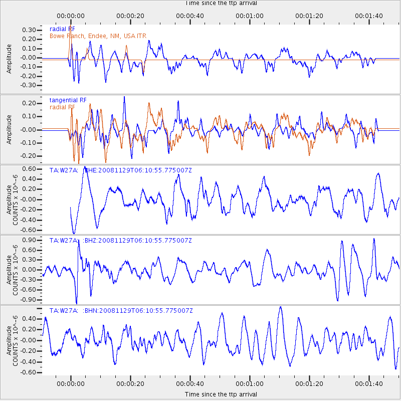
W27A Bowe Ranch, Endee, NM, USA - Earthquake Result Viewer
*The percent match for this event was below the threshold and hence no stack was calculated.
| Earthquake location: |
Fiji Islands Region |
| Earthquake latitude/longitude: |
-18.7/-177.7 |
| Earthquake time(UTC): |
2008/11/29 (334) 05:59:16 GMT |
| Earthquake Depth: |
386 km |
| Earthquake Magnitude: |
5.7 MB, 6.0 MW, 5.9 MW |
| Earthquake Catalog/Contributor: |
WHDF/NEIC |
|
| Network: |
TA USArray Transportable Network (new EarthScope stations) |
| Station: |
W27A Bowe Ranch, Endee, NM, USA |
| Lat/Lon: |
35.06 N/103.06 W |
| Elevation: |
1233 m |
|
| Distance: |
88.7 deg |
| Az: |
52.306 deg |
| Baz: |
246.108 deg |
| Ray Param: |
$rayparam |
*The percent match for this event was below the threshold and hence was not used in the summary stack. |
|
| Radial Match: |
58.03799 % |
| Radial Bump: |
400 |
| Transverse Match: |
56.427044 % |
| Transverse Bump: |
338 |
| SOD ConfigId: |
2658 |
| Insert Time: |
2010-03-06 18:38:36.367 +0000 |
| GWidth: |
2.5 |
| Max Bumps: |
400 |
| Tol: |
0.001 |
|
Signal To Noise
| Channel | StoN | STA | LTA |
| TA:W27A: :BHZ:20081129T06:10:55.775007Z | 2.0524096 | 4.31485E-7 | 2.1023338E-7 |
| TA:W27A: :BHN:20081129T06:10:55.775007Z | 0.8989863 | 1.5423402E-7 | 1.7156438E-7 |
| TA:W27A: :BHE:20081129T06:10:55.775007Z | 0.73780155 | 2.1307935E-7 | 2.8880305E-7 |
| Arrivals |
| Ps | |
| PpPs | |
| PsPs/PpSs | |


