You are here: Home > Network List > CB - China National Seismic Network Stations List
> Station HEH Heihe,Heilongjiang Province > Earthquake Result Viewer
HEH Heihe,Heilongjiang Province - Earthquake Result Viewer
| Earthquake location: |
Irian Jaya, Indonesia |
| Earthquake latitude/longitude: |
-3.9/140.3 |
| Earthquake time(UTC): |
2018/12/16 (350) 09:42:37 GMT |
| Earthquake Depth: |
61 km |
| Earthquake Magnitude: |
6.1 Mww |
| Earthquake Catalog/Contributor: |
NEIC PDE/us |
|
| Network: |
CB China National Seismic Network |
| Station: |
HEH Heihe,Heilongjiang Province |
| Lat/Lon: |
50.25 N/127.41 E |
| Elevation: |
165 m |
|
| Distance: |
55.1 deg |
| Az: |
349.959 deg |
| Baz: |
164.277 deg |
| Ray Param: |
0.06487351 |
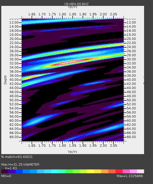
| Estimated Moho Depth: |
31.25 km |
| Estimated Crust Vp/Vs: |
1.83 |
| Assumed Crust Vp: |
6.419 km/s |
| Estimated Crust Vs: |
3.508 km/s |
| Estimated Crust Poisson's Ratio: |
0.29 |
|
| Radial Match: |
93.40821 % |
| Radial Bump: |
309 |
| Transverse Match: |
78.976875 % |
| Transverse Bump: |
400 |
| SOD ConfigId: |
13570011 |
| Insert Time: |
2019-05-02 01:40:49.145 +0000 |
| GWidth: |
2.5 |
| Max Bumps: |
400 |
| Tol: |
0.001 |
|

Signal To Noise
| Channel | StoN | STA | LTA |
| CB:HEH:00:BHZ:20181216T09:51:32.199971Z | 15.818351 | 1.7479423E-6 | 1.1050092E-7 |
| CB:HEH:00:BHN:20181216T09:51:32.199971Z | 8.15286 | 7.4211147E-7 | 9.102468E-8 |
| CB:HEH:00:BHE:20181216T09:51:32.199971Z | 4.639725 | 2.94912E-7 | 6.356239E-8 |
| Arrivals |
| Ps | 4.2 SECOND |
| PpPs | 13 SECOND |
| PsPs/PpSs | 17 SECOND |


