You are here: Home > Network List > CN - Canadian National Seismograph Network Stations List
> Station INK INUVIK, NT > Earthquake Result Viewer
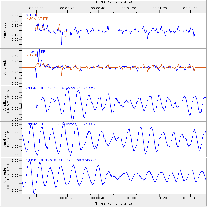
INK INUVIK, NT - Earthquake Result Viewer
*The percent match for this event was below the threshold and hence no stack was calculated.
| Earthquake location: |
Irian Jaya, Indonesia |
| Earthquake latitude/longitude: |
-3.9/140.3 |
| Earthquake time(UTC): |
2018/12/16 (350) 09:42:37 GMT |
| Earthquake Depth: |
61 km |
| Earthquake Magnitude: |
6.1 Mww |
| Earthquake Catalog/Contributor: |
NEIC PDE/us |
|
| Network: |
CN Canadian National Seismograph Network |
| Station: |
INK INUVIK, NT |
| Lat/Lon: |
68.31 N/133.53 W |
| Elevation: |
44 m |
|
| Distance: |
92.2 deg |
| Az: |
21.792 deg |
| Baz: |
265.033 deg |
| Ray Param: |
$rayparam |
*The percent match for this event was below the threshold and hence was not used in the summary stack. |
|
| Radial Match: |
58.75274 % |
| Radial Bump: |
400 |
| Transverse Match: |
78.895905 % |
| Transverse Bump: |
400 |
| SOD ConfigId: |
13570011 |
| Insert Time: |
2019-05-02 01:41:02.219 +0000 |
| GWidth: |
2.5 |
| Max Bumps: |
400 |
| Tol: |
0.001 |
|
Signal To Noise
| Channel | StoN | STA | LTA |
| CN:INK: :BHZ:20181216T09:55:08.974995Z | 2.308318 | 1.4711627E-6 | 6.373311E-7 |
| CN:INK: :BHN:20181216T09:55:08.974995Z | 2.1172526 | 1.2370648E-6 | 5.842783E-7 |
| CN:INK: :BHE:20181216T09:55:08.974995Z | 1.0809377 | 7.348954E-7 | 6.7986844E-7 |
| Arrivals |
| Ps | |
| PpPs | |
| PsPs/PpSs | |


