You are here: Home > Network List > TA - USArray Transportable Network (new EarthScope stations) Stations List
> Station A21K Barrow, AK, USA > Earthquake Result Viewer
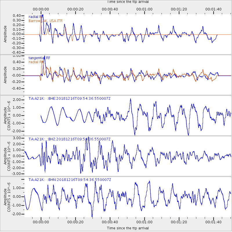
A21K Barrow, AK, USA - Earthquake Result Viewer
*The percent match for this event was below the threshold and hence no stack was calculated.
| Earthquake location: |
Irian Jaya, Indonesia |
| Earthquake latitude/longitude: |
-3.9/140.3 |
| Earthquake time(UTC): |
2018/12/16 (350) 09:42:37 GMT |
| Earthquake Depth: |
61 km |
| Earthquake Magnitude: |
6.1 Mww |
| Earthquake Catalog/Contributor: |
NEIC PDE/us |
|
| Network: |
TA USArray Transportable Network (new EarthScope stations) |
| Station: |
A21K Barrow, AK, USA |
| Lat/Lon: |
71.32 N/156.62 W |
| Elevation: |
577 m |
|
| Distance: |
85.3 deg |
| Az: |
16.756 deg |
| Baz: |
243.224 deg |
| Ray Param: |
$rayparam |
*The percent match for this event was below the threshold and hence was not used in the summary stack. |
|
| Radial Match: |
69.74401 % |
| Radial Bump: |
400 |
| Transverse Match: |
83.86231 % |
| Transverse Bump: |
400 |
| SOD ConfigId: |
13570011 |
| Insert Time: |
2019-05-02 01:42:25.167 +0000 |
| GWidth: |
2.5 |
| Max Bumps: |
400 |
| Tol: |
0.001 |
|
Signal To Noise
| Channel | StoN | STA | LTA |
| TA:A21K: :BHZ:20181216T09:54:36.550007Z | 2.26607 | 1.207957E-6 | 5.330625E-7 |
| TA:A21K: :BHN:20181216T09:54:36.550007Z | 0.96101665 | 7.45216E-7 | 7.754455E-7 |
| TA:A21K: :BHE:20181216T09:54:36.550007Z | 0.72655505 | 4.7377347E-7 | 6.52082E-7 |
| Arrivals |
| Ps | |
| PpPs | |
| PsPs/PpSs | |


