You are here: Home > Network List > TA - USArray Transportable Network (new EarthScope stations) Stations List
> Station G22K Bettles, AK, USA > Earthquake Result Viewer
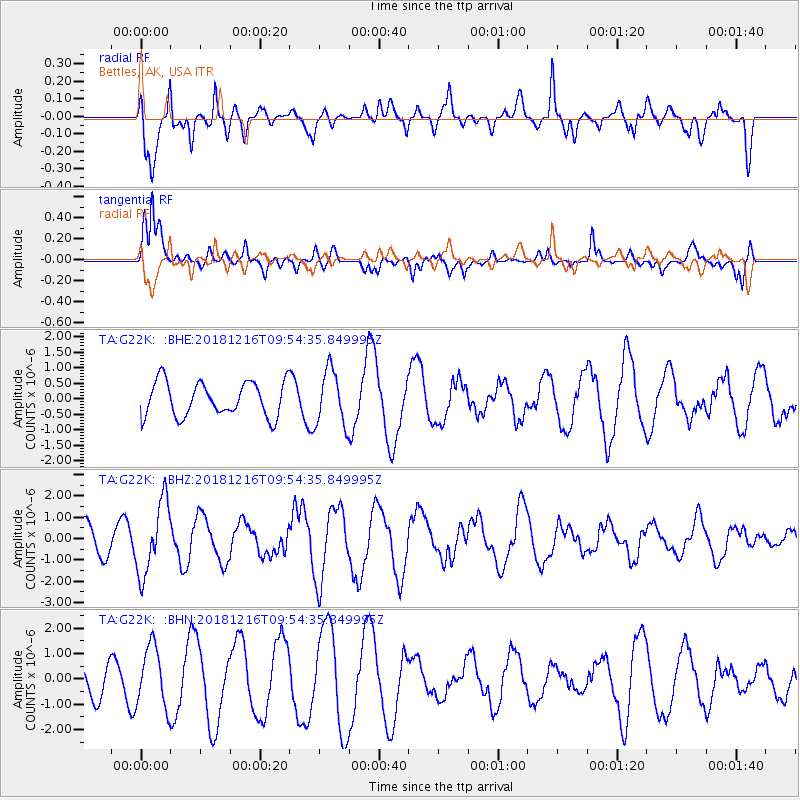
G22K Bettles, AK, USA - Earthquake Result Viewer
*The percent match for this event was below the threshold and hence no stack was calculated.
| Earthquake location: |
Irian Jaya, Indonesia |
| Earthquake latitude/longitude: |
-3.9/140.3 |
| Earthquake time(UTC): |
2018/12/16 (350) 09:42:37 GMT |
| Earthquake Depth: |
61 km |
| Earthquake Magnitude: |
6.1 Mww |
| Earthquake Catalog/Contributor: |
NEIC PDE/us |
|
| Network: |
TA USArray Transportable Network (new EarthScope stations) |
| Station: |
G22K Bettles, AK, USA |
| Lat/Lon: |
66.92 N/151.51 W |
| Elevation: |
205 m |
|
| Distance: |
85.2 deg |
| Az: |
21.553 deg |
| Baz: |
248.396 deg |
| Ray Param: |
$rayparam |
*The percent match for this event was below the threshold and hence was not used in the summary stack. |
|
| Radial Match: |
75.94956 % |
| Radial Bump: |
400 |
| Transverse Match: |
84.007385 % |
| Transverse Bump: |
400 |
| SOD ConfigId: |
13570011 |
| Insert Time: |
2019-05-02 01:42:43.191 +0000 |
| GWidth: |
2.5 |
| Max Bumps: |
400 |
| Tol: |
0.001 |
|
Signal To Noise
| Channel | StoN | STA | LTA |
| TA:G22K: :BHZ:20181216T09:54:35.849995Z | 1.7198793 | 1.6986683E-6 | 9.876671E-7 |
| TA:G22K: :BHN:20181216T09:54:35.849995Z | 1.3080479 | 1.2073425E-6 | 9.2301093E-7 |
| TA:G22K: :BHE:20181216T09:54:35.849995Z | 1.6057425 | 8.866075E-7 | 5.5214804E-7 |
| Arrivals |
| Ps | |
| PpPs | |
| PsPs/PpSs | |


